IMAGES TAKEN NEAR TO
Llanyravon Way, CWMBRAN, NP44 8HP
Introduction
This page details the photographs taken nearby to Llanyravon Way, NP44 8HP by members of the Geograph project.
The Geograph project started in 2005 with the aim of publishing, organising and preserving representative images for every square kilometre of Great Britain, Ireland and the Isle of Man.

There are currently over 7.5m images from over14,400 individuals and you can help contribute to the project by visiting https://www.geograph.org.uk
Image Map
Images are licensed for reuse under creativecommons.org/licenses/by-sa/2.0
Notes
- Clicking on the map will re-center to the selected point.
- The higher the marker number, the further away the image location is from the centre of the postcode.
Image Listing (129 Images Found)
Images are licensed for reuse under creativecommons.org/licenses/by-sa/2.0
Image
Details
Distance
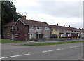
1
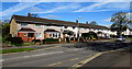
Long row of houses, Llanyravon Way, Cwmbran
Extending for 50 metres along the west side of Llanyravon Way.
Image: © Jaggery
Taken: 12 Apr 2017
0.02 miles
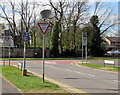
2
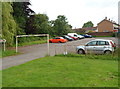
Small car park at the southern end of Llanyravon Way, Cwmbran
Located near the Llanfrechfa Way junction. A goalpost-like metal frame
stops any vehicle above 6' 6" (c2 metres) high entering the car park.
Image: © Jaggery
Taken: 27 Jun 2012
0.03 miles
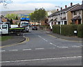
3
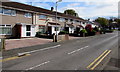
Liswerry Drive houses, Llanyravon, Cwmbran
Houses on the north side of Liswerry Drive viewed from the corner of Llanyravon Way.
The left turn in the distance is into St Bride's Close. http://www.geograph.org.uk/photo/3629015
Image: © Jaggery
Taken: 12 Apr 2017
0.04 miles
4
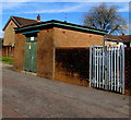
Two Western Power Distribution electricity substations, Llanyravon, Cwmbran
Located near Llanyravon Square shops.
One substation is inside a brick building. The other one is exposed to the elements.
The Western Power Distribution electricity substation identifiers are S/S No. 53-1963/1 and S/S No. 53-1963.
Image: © Jaggery
Taken: 12 Apr 2017
0.05 miles
5
Llanyrafon Way houses, Cwmbran
The houses are on the south side of Llanyrafon Surgery. http://www.geograph.org.uk/photo/1704144
Image: © Jaggery
Taken: 30 Aug 2013
0.05 miles
6
ILDIWCH/GIVE WAY sign facing Llanyravon Way, Llanyravon, Cwmbran
The Welsh/English sign is on the approach to the Llanfrechfa Way junction.
Image: © Jaggery
Taken: 12 Apr 2017
0.05 miles
7
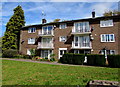
Three-storey block of flats near Llanyravon Square shops, Cwmbran
The flats are on the west side of these shops. http://www.geograph.org.uk/photo/5347037
Image: © Jaggery
Taken: 12 Apr 2017
0.05 miles
8
Caernarvon Crescent, Llanyravon, Cwmbran
Viewed across Llanyravon Way. The spelling Caernarvon suggests that the crescent was named before 1974, the year from which the North Wales town was officially known as Caernarfon in English.
Image: © Jaggery
Taken: 12 Apr 2017
0.05 miles
9
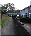
Path to St Bride's Close, Llanyravon, Cwmbran
From the east side of Llanyravon Way.
Image: © Jaggery
Taken: 12 Apr 2017
0.06 miles
10
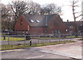
Llanyrafon Surgery, Cwmbran
Located on Llanyrafon Way.
Image: © Jaggery
Taken: 11 Feb 2010
0.06 miles