IMAGES TAKEN NEAR TO
Bryn Milwr, CWMBRAN, NP44 7US
Introduction
This page details the photographs taken nearby to Bryn Milwr, NP44 7US by members of the Geograph project.
The Geograph project started in 2005 with the aim of publishing, organising and preserving representative images for every square kilometre of Great Britain, Ireland and the Isle of Man.

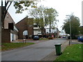
There are currently over 7.5m images from over14,400 individuals and you can help contribute to the project by visiting https://www.geograph.org.uk
Image Map
Images are licensed for reuse under creativecommons.org/licenses/by-sa/2.0
Notes
- Clicking on the map will re-center to the selected point.
- The higher the marker number, the further away the image location is from the centre of the postcode.
Image Listing (24 Images Found)
Images are licensed for reuse under creativecommons.org/licenses/by-sa/2.0
Image
Details
Distance
1
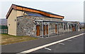
Office and public toilets, Llwyncelyn Cemetery, Cwmbran
Located at the top (western) end of the cemetery which opened in September 2011.
Image: © Jaggery
Taken: 7 Apr 2013
0.11 miles
2
Llwyncelyn Cemetery Cwmbran
Located on high ground on the west side of Hollybush Way, Llwyncelyn Cemetery opened in September 2011. The 11 acre site has capacity for 7,000 graves, which is expected to provide burial spaces for south Torfaen for at least the next 50 years. Planning permission was given in 2009 because of the limited space remaining in the council's cemetery at Panteg. As well as traditional burials, the site offers green burials, which involve caskets or coffins made from biodegradable materials, which do not include a headstone. The cemetery also includes woodland and meadow areas that can be used by the local community. Llwyncelyn, Welsh for Hollybush, was the winner in a Torfaen Council competition to name the cemetery.
Image: © Jaggery
Taken: 7 Apr 2013
0.11 miles
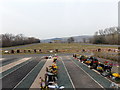
3
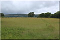
Edge of meadow, Llwyncelyn LNR
Part of the wild flower meadow; the land to the right is designated as a natural burial ground for the adjacent Lwyncelyn Cemetery.
Image: © M J Roscoe
Taken: 13 Jun 2019
0.12 miles
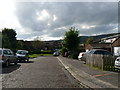
5
East Roedin, Cwmbran
Residential street viewed from the edge of Off Way Stores. http://www.geograph.org.uk/photo/2640331
Image: © Jaggery
Taken: 9 Oct 2011
0.16 miles
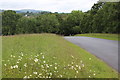
6
Wildflower meadow, Llwyncelyn LNR, Hollybush
Meadow on gentle slope, Mynwent Llwyncelyn, next to cemetery (out of shot, right).
Image: © M J Roscoe
Taken: 13 Jun 2019
0.16 miles
7
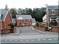
Newer housing, Coed Eva Mill, Cwmbran
Viewed from alongside an older house, Ton Felin. http://www.geograph.org.uk/photo/2639971
Image: © Jaggery
Taken: 9 Oct 2011
0.17 miles
8
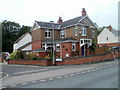
Ton Felin, Coed Eva Mill, Cwmbran
An older detached house in the residential street Coed Eva Mill, surrounded by housing that appears to have been recently built. http://www.geograph.org.uk/photo/2639980
Image: © Jaggery
Taken: 9 Oct 2011
0.17 miles
9
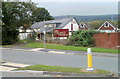
Mill Tavern, Coed Eva, Cwmbran
Pub with its main frontage along a residential street named Coed Eva Mill. This is the other side of the pub, viewed across Two Locks Road.
Image: © Jaggery
Taken: 9 Oct 2011
0.17 miles
10
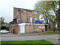
Off Way Stores, Cwmbran
Lifestyle Express store viewed across East Roedin. The street named Offway is a few metres to the west.
Image: © Jaggery
Taken: 9 Oct 2011
0.18 miles