IMAGES TAKEN NEAR TO
Cefn Milwr, CWMBRAN, NP44 7PJ
Introduction
This page details the photographs taken nearby to Cefn Milwr, NP44 7PJ by members of the Geograph project.
The Geograph project started in 2005 with the aim of publishing, organising and preserving representative images for every square kilometre of Great Britain, Ireland and the Isle of Man.

There are currently over 7.5m images from over14,400 individuals and you can help contribute to the project by visiting https://www.geograph.org.uk
Image Map
Images are licensed for reuse under creativecommons.org/licenses/by-sa/2.0
Notes
- Clicking on the map will re-center to the selected point.
- The higher the marker number, the further away the image location is from the centre of the postcode.
Image Listing (56 Images Found)
Images are licensed for reuse under creativecommons.org/licenses/by-sa/2.0
Image
Details
Distance
1
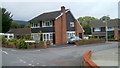
Glan-y-nant Close, Cwmbran
Houses at the western end of the close, viewed across Garth Road.
Image: © Jaggery
Taken: 9 Oct 2011
0.05 miles
2
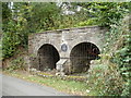
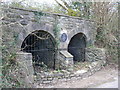
Garth Road lime kilns, Ty Coch, Cwmbran
The plaque states that the early 19th century kilns were restored by Cwmbran Community Council in 1988. Although little is known of the history of the two lime kilns, they had ceased working by 1880. The kilns were used to produce lime by heating limestone at about 900 degrees Celsius. Lime was used for a variety of purposes, such as in the smelting of iron, as a fertiliser, and in making whitewash for exterior walls.
Image: © Jaggery
Taken: 9 Oct 2011
0.06 miles
3
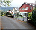
Garth Road houses, Cwmbran
Located near the eastern end of the residential section of Garth Road.
Image: © Jaggery
Taken: 9 Oct 2011
0.06 miles
4
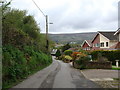
Garth Road beside the disused lime kilns
The lime kilns are shown in image Image
Image: © Ruth Sharville
Taken: 30 Apr 2010
0.07 miles
5
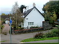
Grade II listed former Glan-y-nant Farmhouse, Cwmbran
Located at the western end of Garth Road. The oldest (western) part of the building is thought to date from the 17th century, with the eastern section probably an early 18th century addition. Grade II listed in September 2002.
Image: © Jaggery
Taken: 9 Oct 2011
0.08 miles
6
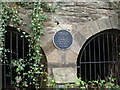
Lime kiln
Early 19 century.Restored by Cwmbran Community Council in 1988
Image: © Colin Madge
Taken: 5 Apr 2008
0.08 miles
8
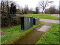
Two Locks Road telecoms cabinets, Cwmbran
Opposite the Ton Road junction.
Image: © Jaggery
Taken: 24 Mar 2018
0.12 miles
9
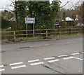
Direction and distance signs, Two Locks Road, Cwmbran
Facing the Cocker Avenue junction, the signs are half a mile from Oakfield
to the left and a quarter of a mile from Hollybush to the right.
Image: © Jaggery
Taken: 24 Mar 2018
0.12 miles
10
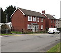
Two Locks Road houses, Cwmbran
Near the Ton Road junction viewed in March 2018.
Rooftop solar panels have been installed since this https://www.geograph.org.uk/photo/2639904 October 2011 photo.
Image: © Jaggery
Taken: 24 Mar 2018
0.13 miles