IMAGES TAKEN NEAR TO
Two Locks Road, CWMBRAN, NP44 7LD
Introduction
This page details the photographs taken nearby to Two Locks Road, NP44 7LD by members of the Geograph project.
The Geograph project started in 2005 with the aim of publishing, organising and preserving representative images for every square kilometre of Great Britain, Ireland and the Isle of Man.

There are currently over 7.5m images from over14,400 individuals and you can help contribute to the project by visiting https://www.geograph.org.uk
Image Map
Images are licensed for reuse under creativecommons.org/licenses/by-sa/2.0
Notes
- Clicking on the map will re-center to the selected point.
- The higher the marker number, the further away the image location is from the centre of the postcode.
Image Listing (96 Images Found)
Images are licensed for reuse under creativecommons.org/licenses/by-sa/2.0
Image
Details
Distance
1
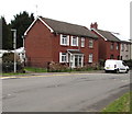
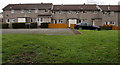
Two Locks Road houses, Cwmbran
Near the Ton Road junction viewed in March 2018.
Rooftop solar panels have been installed since this https://www.geograph.org.uk/photo/2639904 October 2011 photo.
Image: © Jaggery
Taken: 24 Mar 2018
0.01 miles
2
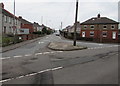
Junction of Cocker Avenue and Two Locks Road, Cwmbran
The southwest end of Cocker Avenue viewed across Two Locks Road.
Image: © Jaggery
Taken: 24 Mar 2018
0.02 miles
3
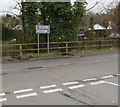
Direction and distance signs, Two Locks Road, Cwmbran
Facing the Cocker Avenue junction, the signs are half a mile from Oakfield
to the left and a quarter of a mile from Hollybush to the right.
Image: © Jaggery
Taken: 24 Mar 2018
0.02 miles
4
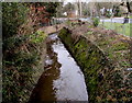
Dowlais Brook below Ton Road, Cwmbran
The brook is a tributary of the Afon Lwyd into which it flows near the SW edge of Ponthir.
Image: © Jaggery
Taken: 24 Mar 2018
0.02 miles
5
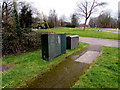
Two Locks Road telecoms cabinets, Cwmbran
Opposite the Ton Road junction.
Image: © Jaggery
Taken: 24 Mar 2018
0.03 miles
6
Ton Road telecoms cabinets, Cwmbran
Viewed across Two Locks Road. BT cabinet on the left. Virgin Media cabinet on the right.
Image: © Jaggery
Taken: 24 Mar 2018
0.03 miles
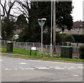
7
Warning sign - Humps for 550 yards, Cocker Avenue, Cwmbran
Near a speed hump, the English/Welsh sign warns of speed humps for 550 yards along Two Locks Road.
Image: © Jaggery
Taken: 24 Mar 2018
0.03 miles
8
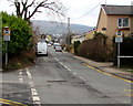
Corner of Two Locks Road and Ton Road, Cwmbran
Two Locks Road houses near the left turn into Ton Road.
Image: © Jaggery
Taken: 9 Oct 2011
0.04 miles
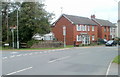
9
Hollybush Close houses, Cwmbran
This part of Hollybush Close is near Dowlais Brook and Ton Road.
Image: © Jaggery
Taken: 24 Mar 2018
0.04 miles
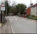
10
Signs near the SE end on Ton Road, Cwmbran
No motors vehicles ahead on Ton Road except for access. The text is also in Welsh.
Image: © Jaggery
Taken: 24 Mar 2018
0.04 miles