IMAGES TAKEN NEAR TO
Kenilworth Place, CWMBRAN, NP44 7JU
Introduction
This page details the photographs taken nearby to Kenilworth Place, NP44 7JU by members of the Geograph project.
The Geograph project started in 2005 with the aim of publishing, organising and preserving representative images for every square kilometre of Great Britain, Ireland and the Isle of Man.

There are currently over 7.5m images from over14,400 individuals and you can help contribute to the project by visiting https://www.geograph.org.uk
Image Map
Images are licensed for reuse under creativecommons.org/licenses/by-sa/2.0
Notes
- Clicking on the map will re-center to the selected point.
- The higher the marker number, the further away the image location is from the centre of the postcode.
Image Listing (160 Images Found)
Images are licensed for reuse under creativecommons.org/licenses/by-sa/2.0
Image
Details
Distance
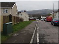
1
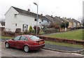
Kenilworth Place, Cwmbran
Viewed from Waun Road.
Image: © Jaggery
Taken: 9 Mar 2013
0.01 miles
2
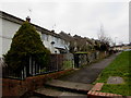
Kenilworth Place in Cwmbran
Steps from Waun Road lead up to a path to Henllys Way past houses in Kenilworth Place.
Image: © Jaggery
Taken: 24 Mar 2018
0.02 miles
3
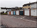
Lock-up garages, Waun Road, Cwmbran
This is one of several groups of lock-up garages hereabouts.
Image: © Jaggery
Taken: 9 Mar 2013
0.02 miles
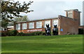
4
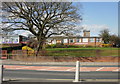
Ysgol Gymraeg, Cwmbran
Viewed from Henllys Way.
Ysgol Gymraeg Cwmbrân is a Welsh language primary school. It opened as an infant and junior school in September 1991 serving the catchment area of Cwmbran town and environs. In September 1997 a nursery class was added to the school.
All pupils from the ages of 3 to 11 are educated through the medium of the Welsh language. English is taught as an additional core subject at Key Stage 2. In September 2008 there were 293 full time pupils enrolled, and 52 part-time nursery pupils.
Image: © Jaggery
Taken: 8 Apr 2010
0.03 miles
5
The Three Bears, Ysgol Gymraeg, Cwmbran
When a local mentioned The Three Bears, I thought it was a pub. But no, it is an unofficial alternative name for Ysgol Gymraeg Cwmbrân. http://www.geograph.org.uk/photo/1794581 This view shows the reason for the name.
Image: © Jaggery
Taken: 9 Oct 2011
0.03 miles
6
West along Waun Road, Cwmbran
Waun Road descends towards Nolton Place and Henllys Way past the left turn
into Ledbrooke Close. A Virgin Media telecoms cabinet is on the left.
Image: © Jaggery
Taken: 24 Mar 2018
0.03 miles
7
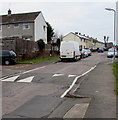
Waun Road speed bump, Cwmbran
Painted white triangles draw attention to the bump, one of several across Waun Road.
Image: © Jaggery
Taken: 24 Mar 2018
0.04 miles
8
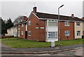
Corner of Ledbrooke Close and Waun Road, Cwmbran
Viewed across Waun Road. Some references show Ledbrook Close, but the name sign on the wall shows Ledbrooke Close.
Image: © Jaggery
Taken: 9 Mar 2013
0.04 miles
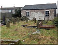
9

Former chapel graveyard, Waun Road, Cwmbran
Located between Waun Road (ahead) and the former Penywaun Independent Chapel. http://www.geograph.org.uk/photo/3365647
The graves in this small burial ground are tightly packed.
Image: © Jaggery
Taken: 9 Mar 2013
0.05 miles
10
Former Penywaun Independent Chapel, Cwmbran
Set back from the north side of Waun Road. A very worn tablet http://www.geograph.org.uk/photo/3365683 on the wall shows the year 1819.
This view was take on March 9th 2013. An estate agents' sign on the Waun Road corner of the chapel showed that this site was to be auctioned on March 27th 2013, at a guide price of £8,000 plus.
The estate agents' website stated that planning permission was granted in October 2009 for change of use to residential and creation of a new access.
Image: © Jaggery
Taken: 9 Mar 2013
0.05 miles