IMAGES TAKEN NEAR TO
Ledbrooke Close, CWMBRAN, NP44 7JT
Introduction
This page details the photographs taken nearby to Ledbrooke Close, NP44 7JT by members of the Geograph project.
The Geograph project started in 2005 with the aim of publishing, organising and preserving representative images for every square kilometre of Great Britain, Ireland and the Isle of Man.

There are currently over 7.5m images from over14,400 individuals and you can help contribute to the project by visiting https://www.geograph.org.uk
Image Map
Images are licensed for reuse under creativecommons.org/licenses/by-sa/2.0
Notes
- Clicking on the map will re-center to the selected point.
- The higher the marker number, the further away the image location is from the centre of the postcode.
Image Listing (160 Images Found)
Images are licensed for reuse under creativecommons.org/licenses/by-sa/2.0
Image
Details
Distance
1
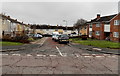
Ledbrooke Close, Cwmbran
Viewed across Waun Road. Some references show Ledbrook Close. The street name sign shows Ledbrooke Close.
Image: © Jaggery
Taken: 9 Mar 2013
0.01 miles
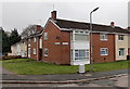
2
East side of Ledbrooke Close, Cwmbran
Looking south from Waun Road.
Image: © Jaggery
Taken: 24 Mar 2018
0.02 miles
3
West along Waun Road, Cwmbran
Waun Road descends towards Nolton Place and Henllys Way past the left turn
into Ledbrooke Close. A Virgin Media telecoms cabinet is on the left.
Image: © Jaggery
Taken: 24 Mar 2018
0.02 miles
4
SW corner of Ledbrooke Close, Cwmbran
Viewed across Waun Road.
Image: © Jaggery
Taken: 9 Mar 2013
0.02 miles
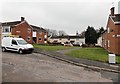
5
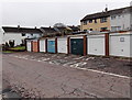
Lock-up garages, Waun Road, Cwmbran
This is one of several groups of lock-up garages hereabouts.
Image: © Jaggery
Taken: 9 Mar 2013
0.04 miles
6
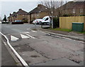
Virgin Media telecoms cabinet, Waun Road, Cwmbran
The dark green cabinet is near one of several speed bumps across Waun Road.
Image: © Jaggery
Taken: 24 Mar 2018
0.04 miles
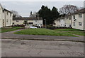
7

Former chapel graveyard, Waun Road, Cwmbran
Located between Waun Road (ahead) and the former Penywaun Independent Chapel. http://www.geograph.org.uk/photo/3365647
The graves in this small burial ground are tightly packed.
Image: © Jaggery
Taken: 9 Mar 2013
0.05 miles
8
Corner of Ledbrooke Close and Waun Road, Cwmbran
Viewed across Waun Road. Some references show Ledbrook Close, but the name sign on the wall shows Ledbrooke Close.
Image: © Jaggery
Taken: 9 Mar 2013
0.05 miles
9
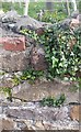
Ordnance Survey Cut Mark
This OS cut mark can be found on the grave yard wall, Waun Road. It marks a point 79.410m above mean sea level.
Image: © Adrian Dust
Taken: 10 Sep 2020
0.05 miles
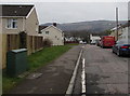
10
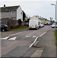
Waun Road speed bump, Cwmbran
Painted white triangles draw attention to the bump, one of several across Waun Road.
Image: © Jaggery
Taken: 24 Mar 2018
0.05 miles