IMAGES TAKEN NEAR TO
Two Locks Road, CWMBRAN, NP44 7HJ
Introduction
This page details the photographs taken nearby to Two Locks Road, NP44 7HJ by members of the Geograph project.
The Geograph project started in 2005 with the aim of publishing, organising and preserving representative images for every square kilometre of Great Britain, Ireland and the Isle of Man.

There are currently over 7.5m images from over14,400 individuals and you can help contribute to the project by visiting https://www.geograph.org.uk
Image Map
Images are licensed for reuse under creativecommons.org/licenses/by-sa/2.0
Notes
- Clicking on the map will re-center to the selected point.
- The higher the marker number, the further away the image location is from the centre of the postcode.
Image Listing (154 Images Found)
Images are licensed for reuse under creativecommons.org/licenses/by-sa/2.0
Image
Details
Distance

2
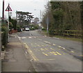
Two Locks Road bus stop, Cwmbran
Near the corner of Cocker Avenue.
Image: © Jaggery
Taken: 24 Mar 2018
0.05 miles
3
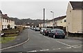
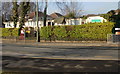
Glyntirion, Cwmbran
Glyntirion is a residential cul-de-sac on the south side of Coed Glas in the Two Locks area of Cwmbran.
Image: © Jaggery
Taken: 9 Mar 2013
0.05 miles
4
Warning sign - Humps for 550 yards, Cocker Avenue, Cwmbran
Near a speed hump, the English/Welsh sign warns of speed humps for 550 yards along Two Locks Road.
Image: © Jaggery
Taken: 24 Mar 2018
0.06 miles
5
Llwyn Celyn, Cwmbran
Houses on Llwyn Celyn viewed from the corner of Two Locks Road.
Image: © Jaggery
Taken: 6 Feb 2010
0.07 miles
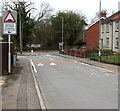
6
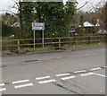
Two Locks Nursery School, Cwmbran
Located roughly halfway along Two Locks Road, near the Llwyn Celyn turning.
Image: © Jaggery
Taken: 6 Feb 2010
0.07 miles
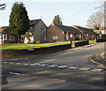
7
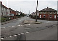
Junction of Cocker Avenue and Two Locks Road, Cwmbran
The southwest end of Cocker Avenue viewed across Two Locks Road.
Image: © Jaggery
Taken: 24 Mar 2018
0.07 miles
8
Direction and distance signs, Two Locks Road, Cwmbran
Facing the Cocker Avenue junction, the signs are half a mile from Oakfield
to the left and a quarter of a mile from Hollybush to the right.
Image: © Jaggery
Taken: 24 Mar 2018
0.07 miles
9
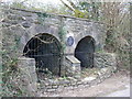
Lime kiln
Early 19 century.Restored by Cwmbran Community Council in 1988
Image: © Colin Madge
Taken: 5 Apr 2008
0.08 miles
10
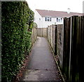
Footpath from Cocker Avenue to Glyntirion, Cwmbran
Viewed from the edge of Cwrt Bleddyn Stores. https://www.geograph.org.uk/photo/5716084
Image: © Jaggery
Taken: 24 Mar 2018
0.09 miles