IMAGES TAKEN NEAR TO
Ty Coch Industrial Estate, Ty Coch Way, CWMBRAN, NP44 7HF
Introduction
This page details the photographs taken nearby to Ty Coch Industrial Estate, Ty Coch Way, NP44 7HF by members of the Geograph project.
The Geograph project started in 2005 with the aim of publishing, organising and preserving representative images for every square kilometre of Great Britain, Ireland and the Isle of Man.

There are currently over 7.5m images from over14,400 individuals and you can help contribute to the project by visiting https://www.geograph.org.uk
Image Map
Images are licensed for reuse under creativecommons.org/licenses/by-sa/2.0
Notes
- Clicking on the map will re-center to the selected point.
- The higher the marker number, the further away the image location is from the centre of the postcode.
Image Listing (108 Images Found)
Images are licensed for reuse under creativecommons.org/licenses/by-sa/2.0
Image
Details
Distance
1
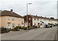
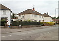
Mixed housing, Fields Road, Cwmbran
There is a mixture of semi-detached and terrace housing on the west side of Fields Road between The Close and East Road.
Image: © Jaggery
Taken: 30 Jul 2010
0.05 miles
2
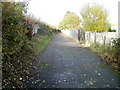
Path alongside Fields Road, Cwmbran
The path is between Fields Road houses on the right, and a fence and hedges at the edge of Cwmbran Drive (A4051).
Image: © Jaggery
Taken: 27 Oct 2010
0.05 miles
3
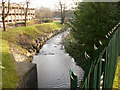
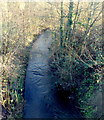
Dowlais Brook, Cwmbran
Dowlais Brook flows SE away from the east side of Ty Coch Way. The brook empties into the Afon Lwyd near the SW edge of Ponthir.
Image: © Jaggery
Taken: 6 Feb 2010
0.08 miles
4
Corner of East Road and Fields Road, Oakfield, Cwmbran
Looking across Fields Road. East Road heads off on the right towards Green Willows, about 300 metres away.
Image: © Jaggery
Taken: 30 Jul 2010
0.08 miles
5

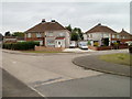
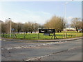
New business premises for sale or to let, Ty Coch Way, Cwmbran
At the date of this photo, early February 2010, this new building on the east side on Ty Coch Way was unoccupied.
Image: © Jaggery
Taken: 6 Feb 2010
0.10 miles
6
Festive corner, Ty Coch Way, Cwmbran
The Festive sign on the edge of Ty Coch Way is at the entrance drive http://www.geograph.org.uk/photo/1977357 to Festive Productions premises.
Image: © Jaggery
Taken: 6 Feb 2010
0.10 miles
7

Building skeleton, Ty Coch Way, Cwmbran
In front of Western Power Distribution's Ty Coch depot, on the east side of Ty Coch Way, a new building is being erected.
Image: © Jaggery
Taken: 6 Feb 2010
0.10 miles
8

Entrance to ambulance headquarters, Cwmbran
The entrance is from Ty Coch Way into the Regional Ambulance Headquarters and Clinical Contact Centre.
Image: © Jaggery
Taken: 6 Feb 2010
0.10 miles
9
Dowlais Brook flows away from Cwmbran Drive, Cwmbran
The brook flows east towards its confluence with the Afon Lwyd, about 4km away.
Image: © Jaggery
Taken: 1 Dec 2012
0.11 miles
10
The Close, Oakfield, Cwmbran
Houses on the west side of The Close, viewed from the corner of Fields Road.
The Close is not a close, as it is connected to Fields Road and The Highway.
It may be that the local street naming department had an uninspired day when naming The Close and The Highway. Another possibility is that these were the original streets in Oakfield when all else around was undeveloped. That was the case in New Inn, where the first streets named were The Highway http://www.geograph.org.uk/photo/1666569 and The Avenue. http://www.geograph.org.uk/photo/1666551
Image: © Jaggery
Taken: 30 Jul 2010
0.11 miles