IMAGES TAKEN NEAR TO
Mere Path, CWMBRAN, NP44 4SL
Introduction
This page details the photographs taken nearby to Mere Path, NP44 4SL by members of the Geograph project.
The Geograph project started in 2005 with the aim of publishing, organising and preserving representative images for every square kilometre of Great Britain, Ireland and the Isle of Man.

There are currently over 7.5m images from over14,400 individuals and you can help contribute to the project by visiting https://www.geograph.org.uk
Image Map
Images are licensed for reuse under creativecommons.org/licenses/by-sa/2.0
Notes
- Clicking on the map will re-center to the selected point.
- The higher the marker number, the further away the image location is from the centre of the postcode.
Image Listing (100 Images Found)
Images are licensed for reuse under creativecommons.org/licenses/by-sa/2.0
Image
Details
Distance
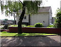
1
Archer Road, Cwmbran
The cul-de-sac Archer Road descends from the south side of Ty Gwyn Road.
Image: © Jaggery
Taken: 30 May 2016
0.07 miles
2
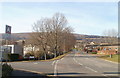
SE section of Ty Gwyn Road, Cwmbran
The view NW along Ty Gwyn Road. On the left is the top (NE) end of Fairhill. A few tens of metres ahead on the right is the turning for Berthin.
Image: © Jaggery
Taken: 30 Jan 2011
0.07 miles
3

Junction of Fairhill and Byways, Greenmeadow, Cwmbran
Byways ascends from Fairhill. This is one of two junctions of Fairhill and Byways.
The other one http://www.geograph.org.uk/photo/5151538 is 220 metres to the southwest.
Image: © Jaggery
Taken: 10 Oct 2016
0.08 miles
4

Warning sign - Patrol/Hebryngwr, Fairhill, Greenmeadow, Cwmbran
The bilingual (English/Welsh) sign faces Fairhill in the Greenmeadow area of Cwmbran.
The Stagecoach bus is on Route 5 to Cwmbran bus station.
Image: © Jaggery
Taken: 10 Oct 2016
0.08 miles
5
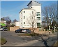
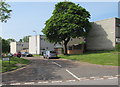
Maybury House, Cwmbran
5-storey block of flats on the corner of Fairhill and Byways in the Greenmeadow area of Cwmbran.
Image: © Jaggery
Taken: 30 Jan 2011
0.08 miles
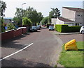
6

Badgers Mede, Greenmeadow, Cwmbran
Badgers Mede is a cul-de-sac on the north side of the road named Fairhill.
An Asda home delivery van is parked in front of lockup garages.
Image: © Jaggery
Taken: 10 Oct 2016
0.09 miles
7
Northern end of Pennyfields, Cwmbran
Viewed across Archer Road near the corner of Ty Gwyn Road.
The name on the house wall is PENNYFIELDS, which is an area of twenty houses.
Image: © Jaggery
Taken: 30 May 2016
0.09 miles
8

Two bus stops, Fairhill, Greenmeadow, Cwmbran
The stops alongside Fairhill are on Stagecoach Route 5 to and from Cwmbran bus station.
Only the stop on the left has a shelter. The left turn ahead is into Badgers Mede. http://www.geograph.org.uk/photo/5151588
Image: © Jaggery
Taken: 10 Oct 2016
0.10 miles
9

Ellwood Path, Greenmeadow, Cwmbran
Ellwood Path descends from the south side of Fairhill.
Image: © Jaggery
Taken: 10 Oct 2016
0.10 miles
10
Ravenscourt, Cwmbran
Viewed across Ty Gwyn Road. The name sign http://www.geograph.org.uk/photo/5104819 on the left shows that Ravenscourt leads to houses in Clyffes and Marloes Path.
Image: © Jaggery
Taken: 30 May 2016
0.10 miles