IMAGES TAKEN NEAR TO
Grange Road, CWMBRAN, NP44 3XU
Introduction
This page details the photographs taken nearby to Grange Road, NP44 3XU by members of the Geograph project.
The Geograph project started in 2005 with the aim of publishing, organising and preserving representative images for every square kilometre of Great Britain, Ireland and the Isle of Man.

There are currently over 7.5m images from over14,400 individuals and you can help contribute to the project by visiting https://www.geograph.org.uk
Image Map
Images are licensed for reuse under creativecommons.org/licenses/by-sa/2.0
Notes
- Clicking on the map will re-center to the selected point.
- The higher the marker number, the further away the image location is from the centre of the postcode.
Image Listing (612 Images Found)
Images are licensed for reuse under creativecommons.org/licenses/by-sa/2.0
Image
Details
Distance
1
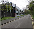
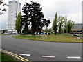
Grange Road offices, Cwmbran
At the edge of the Meritor Heavy Vehicle Braking Systems (UK) site.
Image: © Jaggery
Taken: 14 Apr 2017
0.03 miles
2
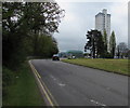
Bend in St Davids Road Cwmbran
On the approach to the roundabout at the Tudor Road junction. Cwmbran's tallest
building, Bron Afon Housing Association's The Tower Block, is in the background.
Image: © Jaggery
Taken: 14 Apr 2017
0.05 miles
3
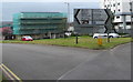
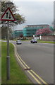
Direction signs at a Cwmbran junction
Viewed across St David's Road at the Tudor Road junction.
Image: © Jaggery
Taken: 14 Apr 2017
0.06 miles
4
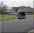
X24 bus in St Davids Road Cwmbran
The Stagecoach Gold bus is on route X24 to Market Square bus station in Newport.
Image: © Jaggery
Taken: 14 Apr 2017
0.06 miles
5
Roundabout in Southville, Cwmbran
In the middle of the junction of St Davids Road and Tudor Road. Cwmbran's tallest
building, Bron Afon Housing Association's The Tower Block, is in the background.
Image: © Jaggery
Taken: 14 Apr 2017
0.06 miles
6
Warning sign - two-way traffic, St David's Road, Southville, Cwmbran
In the background, work on the St David's Road housing regeneration scheme is ongoing in April 2017.
Image: © Jaggery
Taken: 14 Apr 2017
0.06 miles
7
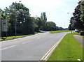
Cwmbran : St David's Road splits into two carriageways ahead
A view south towards a grass triangle separating the carriageways of St David's Road at the approach to the roundabout at the Tudor Road and Glyndwr Road junction.
Image: © Jaggery
Taken: 26 Jul 2012
0.06 miles
8
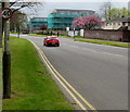
40mph speed limit sign, St David's Road, Southville, Cwmbran
In the background, work on the St David's Road housing regeneration scheme is ongoing in April 2017.
Image: © Jaggery
Taken: 14 Apr 2017
0.07 miles
9
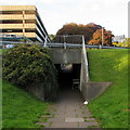
Abandoned trolley in a St David's Road underpass, Cwmbran
A shopping trolley has been left in the pedestrian underpass below St David's Road.
Image: © Jaggery
Taken: 5 Oct 2016
0.07 miles
10
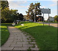
St David's Road direction sign, Southville, Cwmbran
Facing northbound traffic on St David's Road. Turn left (into Tudor Road) for Cwmbran police station.
Two abandoned shopping trolleys are near the pedestrian underpass ahead.
Image: © Jaggery
Taken: 5 Oct 2016
0.07 miles