IMAGES TAKEN NEAR TO
Tintern Close, CWMBRAN, NP44 3PT
Introduction
This page details the photographs taken nearby to Tintern Close, NP44 3PT by members of the Geograph project.
The Geograph project started in 2005 with the aim of publishing, organising and preserving representative images for every square kilometre of Great Britain, Ireland and the Isle of Man.

There are currently over 7.5m images from over14,400 individuals and you can help contribute to the project by visiting https://www.geograph.org.uk
Image Map
Images are licensed for reuse under creativecommons.org/licenses/by-sa/2.0
Notes
- Clicking on the map will re-center to the selected point.
- The higher the marker number, the further away the image location is from the centre of the postcode.
Image Listing (439 Images Found)
Images are licensed for reuse under creativecommons.org/licenses/by-sa/2.0
Image
Details
Distance
1
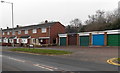
Houses and lockup garages, Llywelyn Road, Cwmbran
This part of Llywelyn Road is opposite Radnor Way.
Image: © Jaggery
Taken: 20 Feb 2013
0.04 miles
2
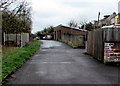
Unnamed lane SE of a free car park in Old Cwmbran
Viewed from the edge of this http://www.geograph.org.uk/photo/4410936 car park. The lane ends at concrete posts a few metres from Grange Road.
Image: © Jaggery
Taken: 2 Apr 2015
0.05 miles
3
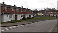
Houses at the southern end of Radnor Way, Cwmbran
The house are between the Whitebrook Way junction on the left and Llywelyn Road.
Image: © Jaggery
Taken: 3 Feb 2014
0.06 miles
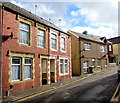
4

Talgarth Close, Cwmbran
Talgarth Close is a short cul-de-sac on the south side of Llywelyn Road.
Image: © Jaggery
Taken: 30 Aug 2011
0.06 miles
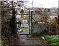
5
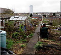
Allotments path, Old Cwmbran
Viewed from this http://www.geograph.org.uk/photo/4410901 entrance gate. The multi-storey flats building The Tower http://www.geograph.org.uk/photo/3828457 is in the distance.
Image: © Jaggery
Taken: 2 Apr 2015
0.06 miles
6
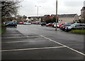
Large free car park, Old Cwmbran
I wondered whether this site on flat land east of Victoria Street had formerly been a railway yard.
Image: © Jaggery
Taken: 2 Apr 2015
0.07 miles
7
Exit road from an Old Cwmbran car park
Towards the camera in Ventnor Road near the Victoria Street junction.
DIM on the road surface is half of the Welsh phrase meaning No Entry.
Image: © Jaggery
Taken: 15 May 2020
0.07 miles
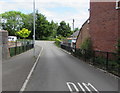
8
Ventnor Road, Old Cwmbran
Double yellow lines on both sides indicate no parking at any time.
Image: © Jaggery
Taken: 23 Sep 2016
0.07 miles
9
No tipping and no more grass in Old Cwmbran allotments
Notices at the entrance to allotments http://www.geograph.org.uk/photo/4410912 from a car park on the east side of Victoria Street, Old Cwmbran.
Image: © Jaggery
Taken: 2 Apr 2015
0.07 miles
10
Whitebrook Way houses, Cwmbran
Houses on the north side of Whitebrook Way, viewed from Radnor Road.
The Tower Block http://www.geograph.org.uk/photo/1611824 is in the background.
Image: © Jaggery
Taken: 20 Feb 2013
0.08 miles