IMAGES TAKEN NEAR TO
Abbey Road, CWMBRAN, NP44 3JL
Introduction
This page details the photographs taken nearby to Abbey Road, NP44 3JL by members of the Geograph project.
The Geograph project started in 2005 with the aim of publishing, organising and preserving representative images for every square kilometre of Great Britain, Ireland and the Isle of Man.

There are currently over 7.5m images from over14,400 individuals and you can help contribute to the project by visiting https://www.geograph.org.uk
Image Map
Images are licensed for reuse under creativecommons.org/licenses/by-sa/2.0
Notes
- Clicking on the map will re-center to the selected point.
- The higher the marker number, the further away the image location is from the centre of the postcode.
Image Listing (369 Images Found)
Images are licensed for reuse under creativecommons.org/licenses/by-sa/2.0
Image
Details
Distance
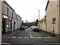
1
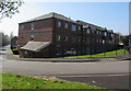
Waterside Court, Cwmbran
Waterside Court is a Melin Homes sheltered housing scheme located near the disused
Monmouthshire & Brecon Canal. Viewed from the junction of Abbey Road and Star Street.
Image: © Jaggery
Taken: 9 Apr 2017
0.02 miles
2
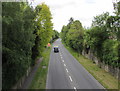
SSE along Cwmbran Drive from Old Cwmbran
The A4051 Cwmbran Drive viewed from the Commercial Street bridge in May 2020. Ahead for Newport.
Image: © Jaggery
Taken: 15 May 2020
0.03 miles
3
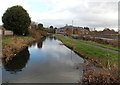
Disused canal in Old Cwmbran
A long disused section of the Monmouthshire & Brecon canal,
viewed looking ENE from Broadweir Road on this http://www.geograph.org.uk/photo/4272792 bridge.
Image: © Jaggery
Taken: 7 Dec 2014
0.03 miles
4
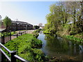
Canal fragment alongside Star Street, Old Cwmbran
A long disused disconnected section of the Monmouthshire & Brecon Canal.
Cwmbran Iron Works were formerly nearby. http://www.geograph.org.uk/photo/5345456
Image: © Jaggery
Taken: 9 Apr 2017
0.03 miles
5
The Council House, Old Cwmbran
Located on the corner of Victoria Street and Ventnor Road.
Since April 1991, the building has been the premises of Cwmbran Community Council, which came into being following the 1974 local government reorganisation. Formerly, the Victorian building was used as a police station and court.
Image: © Jaggery
Taken: 31 Dec 2009
0.03 miles
6
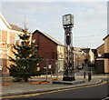
The Council House Clock Tower, Old Cwmbran
The clock tower was erected outside The Council House http://www.geograph.org.uk/photo/1647395 in 1936 as a memorial to the men of Cwmbran who were killed in the Great War 1914-1918.
http://www.geograph.org.uk/photo/1647407 to the inscription on the north side.
http://www.geograph.org.uk/photo/1647424 to the inscription on the south side.
Image: © Jaggery
Taken: 31 Dec 2009
0.03 miles
7
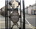
The Council House Clock Tower inscription, north side, Old Cwmbran
The inscription on the north side of the clock tower http://www.geograph.org.uk/photo/1647404 reads
THIS CLOCK TOWER WAS ERECTED BY THE URBAN DISTRICT COUNCIL OF CWMBRAN
W.E.BROWN, C.C., J.P. Chairman
WILLIAM CLARK, Clerk
FEBRUARY 1936
http://www.geograph.org.uk/photo/1647424 to the inscription on the other side.
To the left is Ventnor Road ; to the right is Victoria Street.
Image: © Jaggery
Taken: 31 Dec 2009
0.03 miles
8
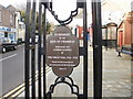
The Council House Clock Tower inscription, south side, Old Cwmbran
The inscription on the south side of the clock tower http://www.geograph.org.uk/photo/1647404 reads
IN MEMORY OF THE MEN OF CWMBRAN WHO MADE THE SUPREME SACRIFICE IN THE GREAT WAR, 1914-1918
"Greater love hath no man than this
that a man lay down his life for his friends"
John xv. 13
http://www.geograph.org.uk/photo/1647407 to the inscription on the other side.
Image: © Jaggery
Taken: 31 Dec 2009
0.03 miles
9
Malpas Street, Old Cwmbran
Viewed from Victoria Street. The far end of Malpas Street is adjacent to Cwmbran Drive (A4051), formerly railway tracks.
The Vitriol Works, locally known as the 'Chem', manufactured sulphuric acid at premises located at the end of Malpas Street. The works, owned by Cwmbran Chemical Co., opened in the 1860s. It became part of ICI in the 1920s but closed down around 1930. The buildings were demolished in the late 1950s.
Image: © Jaggery
Taken: 31 Dec 2009
0.03 miles
10

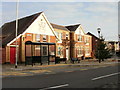
Rose & Crown, Old Cwmbran
Located on Victoria Street, near the Commercial Street junction.
Image: © Jaggery
Taken: 31 Dec 2009
0.03 miles