IMAGES TAKEN NEAR TO
Llantarnam Gardens, CWMBRAN, NP44 3HN
Introduction
This page details the photographs taken nearby to Llantarnam Gardens, NP44 3HN by members of the Geograph project.
The Geograph project started in 2005 with the aim of publishing, organising and preserving representative images for every square kilometre of Great Britain, Ireland and the Isle of Man.

There are currently over 7.5m images from over14,400 individuals and you can help contribute to the project by visiting https://www.geograph.org.uk
Image Map
Images are licensed for reuse under creativecommons.org/licenses/by-sa/2.0
Notes
- Clicking on the map will re-center to the selected point.
- The higher the marker number, the further away the image location is from the centre of the postcode.
Image Listing (193 Images Found)
Images are licensed for reuse under creativecommons.org/licenses/by-sa/2.0
Image
Details
Distance
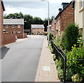
2
John Fielding Gardens, Llantarnam
Viewed from Newport Road. http://www.geograph.org.uk/photo/1611672 to a potted history of John Fielding VC, who is buried in the churchyard nearby.
Image: © Jaggery
Taken: 24 Feb 2010
0.03 miles
3
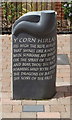
John Fielding VC memorial, Llantarnam
This memorial is of a Hirlas horn - y Corn Hirlas - used by the ancient Welsh both for feasting and to sound a warning of the approach of enemies. It stands in John Fielding Gardens, an area of new Redrow houses on the west side of Newport Road. It was unveiled in January 2008.
The small plaque in the ground in front of the memorial records
Sculpture by Teucer Wilson to commemorate
1395 Private John Williams (Fielding)
2nd Battalion, 24th Regiment of Foot
24th May 1857 - 25th November 1932
One of the heroes of the Battle at Rorke's Drift
Commissioned by Torfaen County Borough Council & the
Community of Llantarnam. Sponsored by Redrow Homes
John Fielding's grave http://www.geograph.org.uk/photo/2007085 is in the nearby churchyard
Image: © Jaggery
Taken: 7 Aug 2010
0.03 miles
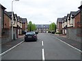
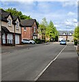
4
Corner of John Fielding Gardens, Llantarnam
The course of the cul-de-sac John Fielding Gardens is an inverted L shape from Newport Road. This view is of houses at the corner (the angle of the L).
On the right, in front of the door, is a memorial http://www.geograph.org.uk/photo/2074219 to John Fielding VC.
Image: © Jaggery
Taken: 7 Aug 2010
0.03 miles
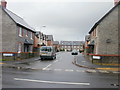
5
The view from the far end of John Fielding Gardens, Llantarnam
The course of the cul-de-sac John Fielding Gardens is an inverted L shape from Newport Road.
This view is from the far end, looking towards the corner http://www.geograph.org.uk/photo/2074239 (the angle of the L).
Image: © Jaggery
Taken: 7 Aug 2010
0.03 miles
6
Houses in John Fielding Gardens, Llantarnam, Cwmbran
Looking to the NW from near the corner of Newport Road.
Image: © Jaggery
Taken: 5 May 2022
0.05 miles
7
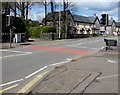
Pelican crossing near John Fielding Gardens, Llantarnam, Cwmbran
A sign on a lamppost shows that the speed limit on this part of Newport Road is 40mph in April 2016.
Image: © Jaggery
Taken: 16 Apr 2016
0.06 miles
8
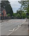
Pelican crossing, Newport Road, Llantarnam, Cwmbran
Chambers Dictionary states that pelican in this context
is adapted from "pedestrian light controlled crossing".
Image: © Jaggery
Taken: 5 May 2022
0.06 miles
9

Narrow bus shelter, Newport Road, Llantarnam, Cwmbran
Alongside a stop for buses to Cwmbran Bus Station.
Image: © Jaggery
Taken: 5 May 2022
0.06 miles
10
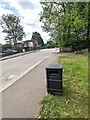
Dog waste bin alongside Newport Road, Llantarnam, Cwmbran
Text on the bin shows that "Dog Waste" is "Gwastraff Ci" in Welsh.
Image: © Jaggery
Taken: 5 May 2022
0.06 miles