IMAGES TAKEN NEAR TO
Fields Road, CWMBRAN, NP44 3EQ
Introduction
This page details the photographs taken nearby to Fields Road, NP44 3EQ by members of the Geograph project.
The Geograph project started in 2005 with the aim of publishing, organising and preserving representative images for every square kilometre of Great Britain, Ireland and the Isle of Man.

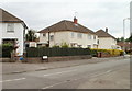
There are currently over 7.5m images from over14,400 individuals and you can help contribute to the project by visiting https://www.geograph.org.uk
Image Map
Images are licensed for reuse under creativecommons.org/licenses/by-sa/2.0
Notes
- Clicking on the map will re-center to the selected point.
- The higher the marker number, the further away the image location is from the centre of the postcode.
Image Listing (126 Images Found)
Images are licensed for reuse under creativecommons.org/licenses/by-sa/2.0
Image
Details
Distance
1
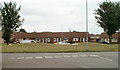
Row of bungalows, The Highway, Oakfield, Cwmbran
Viewed from the corner of The Close. This is the middle block of three rows of bungalows forming and arc in the central part of The Highway.
Image: © Jaggery
Taken: 30 Jul 2010
0.05 miles
2
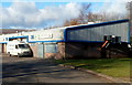
Mark's Meats premises and van, Llantarnam Park, Cwmbran
Caterting and wholesale butcher located in Unit 36, Llantarnam Park.
Image: © Jaggery
Taken: 1 Dec 2012
0.06 miles
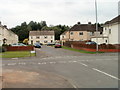
3
Abbey Green, Cwmbran
A cul-de-sac on the north side of Fields Road.
Image: © Jaggery
Taken: 30 Jul 2010
0.06 miles
4
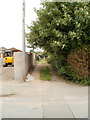
Path north from Fields Road, Cwmbran
A path - or is it a track ? - heads away from the north side of Fields Road. It ends at East Road, about 200 metres away.
Image: © Jaggery
Taken: 30 Jul 2010
0.06 miles
5
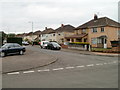
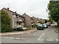
Corner of South Road and Fields Road, Cwmbran
Houses on the east side of South Road, near the corner of Fields Road.
Image: © Jaggery
Taken: 30 Jul 2010
0.06 miles
6
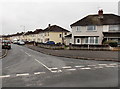
South Road, Oakfield, Cwmbran
Viewed across East Road.
Image: © Jaggery
Taken: 9 Mar 2013
0.07 miles
7
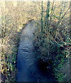
Dowlais Brook flows away from Cwmbran Drive, Cwmbran
The brook flows east towards its confluence with the Afon Lwyd, about 4km away.
Image: © Jaggery
Taken: 1 Dec 2012
0.08 miles
8
The southern end of South Road, Cwmbran
South Road began about 200 metres behind the camera. Its final 60 metres or so is ahead, on the far side of Fields Road.
Image: © Jaggery
Taken: 30 Jul 2010
0.08 miles
9

The Window Doctor, Llantarnam Park, Cwmbran
Located in Unit 33 at the northern edge of Llantarnam Park.
The Window Doctor's business is sales, installation and repairs
of uPVC windows & frames, doors, conservatories and porches.
Next door in Unit 32 is Delta Pattern Ltd.
Image: © Jaggery
Taken: 1 Dec 2012
0.08 miles
10
The Close, Oakfield, Cwmbran
Houses on the west side of The Close, viewed from the corner of Fields Road.
The Close is not a close, as it is connected to Fields Road and The Highway.
It may be that the local street naming department had an uninspired day when naming The Close and The Highway. Another possibility is that these were the original streets in Oakfield when all else around was undeveloped. That was the case in New Inn, where the first streets named were The Highway http://www.geograph.org.uk/photo/1666569 and The Avenue. http://www.geograph.org.uk/photo/1666551
Image: © Jaggery
Taken: 30 Jul 2010
0.08 miles