IMAGES TAKEN NEAR TO
Green Willows, CWMBRAN, NP44 3DZ
Introduction
This page details the photographs taken nearby to Green Willows, NP44 3DZ by members of the Geograph project.
The Geograph project started in 2005 with the aim of publishing, organising and preserving representative images for every square kilometre of Great Britain, Ireland and the Isle of Man.

There are currently over 7.5m images from over14,400 individuals and you can help contribute to the project by visiting https://www.geograph.org.uk
Image Map
Images are licensed for reuse under creativecommons.org/licenses/by-sa/2.0
Notes
- Clicking on the map will re-center to the selected point.
- The higher the marker number, the further away the image location is from the centre of the postcode.
Image Listing (156 Images Found)
Images are licensed for reuse under creativecommons.org/licenses/by-sa/2.0
Image
Details
Distance
1
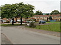
Plas Cwrt, Oakfield, Cwmbran
Plas Cwrt is an L-shaped area of housing on the north side of Brangwyn Avenue,
near its junction with Green Willows.
Image: © Jaggery
Taken: 30 Jul 2010
0.03 miles
2
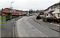
Green Willows, Oakfield, Cwmbran
Green Willows is one of the main roads through the Oakfield area of Cwmbran.
This view is southwards from near The Oakfield pub http://www.geograph.org.uk/photo/3363082 on the corner of Croeswen.
Image: © Jaggery
Taken: 9 Mar 2013
0.05 miles
3

Green Willows houses, Oakfield, Cwmbran
South of the Ash Green junction.
Image: © Jaggery
Taken: 23 Mar 2018
0.06 miles
4

Green Willows, Cwmbran
Houses in an L-shaped alignment are at the southern end of Green Willows, viewed from the edge of Brangwyn Avenue. The northern end of Green Willows, about 450 metres behind the camera, connects with Oakfield Road.
Image: © Jaggery
Taken: 30 Jul 2010
0.07 miles
5
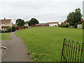
Open space north of Brangwyn Avenue, Cwmbran
A long but narrow strip of grass extends north from Brangwyn Avenue, heading for the southern edge of Oakfield Primary School.
Image: © Jaggery
Taken: 30 Jul 2010
0.07 miles
6

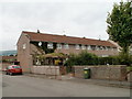
The Oakfield, Oakfield, Cwmbran
Pub with the same name as the area of Cwmbran in which it is located,
on the corner of Green Willows and Croeswen.
Image: © Jaggery
Taken: 30 Jul 2010
0.08 miles
7
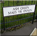
Ash Green/Maes yr Onnen name sign, Oakfield, Cwmbran
The English/Welsh sign is on the left here. https://www.geograph.org.uk/photo/5715055
Image: © Jaggery
Taken: 23 Mar 2018
0.08 miles
8
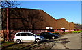
Units in Llantarnam Industrial Estate, Cwmbran
These units extend for 150 metres from the edge of Llantarnam Park Way on this side,
to the south bank of Dowlais Brook. Unit 56 is nearest the camera.
Image: © Jaggery
Taken: 29 Dec 2014
0.09 miles
9
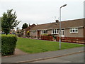
Brangwyn Avenue bungalows, Llantarnam
The bungalows are aligned at right angles to the north side of Brangwyn Avenue.
Image: © Jaggery
Taken: 30 Jul 2010
0.09 miles
10
Brangwyn Avenue housing, Llantarnam
Housing in this section of Brangwyn Avenue is aligned at right angles to the roadway.
These nearby bungalows http://www.geograph.org.uk/photo/1987958 are another example of this alignment.
Image: © Jaggery
Taken: 30 Jul 2010
0.09 miles