IMAGES TAKEN NEAR TO
The Highway, CWMBRAN, NP44 3DR
Introduction
This page details the photographs taken nearby to The Highway, NP44 3DR by members of the Geograph project.
The Geograph project started in 2005 with the aim of publishing, organising and preserving representative images for every square kilometre of Great Britain, Ireland and the Isle of Man.

There are currently over 7.5m images from over14,400 individuals and you can help contribute to the project by visiting https://www.geograph.org.uk
Image Map
Images are licensed for reuse under creativecommons.org/licenses/by-sa/2.0
Notes
- Clicking on the map will re-center to the selected point.
- The higher the marker number, the further away the image location is from the centre of the postcode.
Image Listing (134 Images Found)
Images are licensed for reuse under creativecommons.org/licenses/by-sa/2.0
Image
Details
Distance
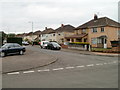
1
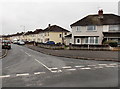
South Road, Oakfield, Cwmbran
Viewed across East Road.
Image: © Jaggery
Taken: 9 Mar 2013
0.03 miles
2
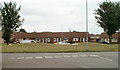
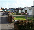
Row of bungalows, The Highway, Oakfield, Cwmbran
Viewed from the corner of The Close. This is the middle block of three rows of bungalows forming and arc in the central part of The Highway.
Image: © Jaggery
Taken: 30 Jul 2010
0.03 miles
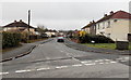
3
Abbey Green, Cwmbran
A cul-de-sac on the north side of Fields Road.
Image: © Jaggery
Taken: 30 Jul 2010
0.07 miles
4
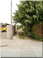
Path north from Fields Road, Cwmbran
A path - or is it a track ? - heads away from the north side of Fields Road. It ends at East Road, about 200 metres away.
Image: © Jaggery
Taken: 30 Jul 2010
0.07 miles
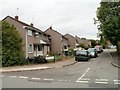
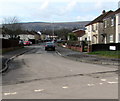
5
Corner of South Road and Fields Road, Cwmbran
Houses on the east side of South Road, near the corner of Fields Road.
Image: © Jaggery
Taken: 30 Jul 2010
0.07 miles
6
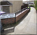
Path from Green Willows to Abbey Green, Oakfield, Cwmbran
The sign shows that Abbey Green is Maes yr Abaty in Welsh.
Image: © Jaggery
Taken: 23 Mar 2018
0.07 miles
7
East Road, Oakfield, Cwmbran
Viewed across Green Willows.
East Road is in a part of Oakfield with prosaic street names. Other examples are South Road, Fields Road, The Highway and The Close. The local council's street naming department must have had an off day if the best they could come up with was The Close and The Highway...
Image: © Jaggery
Taken: 9 Mar 2013
0.07 miles
8
West along East Road, Oakfield, Cwmbran
From the road named Green Willows along East Road towards South Road and The Highway.
Image: © Jaggery
Taken: 23 Mar 2018
0.08 miles
9
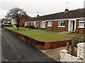
Bungalows, Oakfield Road, Cwmbran
Looking ESE along the south side of Oakfield Road, in the direction of the turning for the residential road Green Willows.
Image: © Jaggery
Taken: 27 Oct 2010
0.08 miles
10
East Road bungalows, Oakfield, Cwmbran
The bungalows face South Road. http://www.geograph.org.uk/photo/3363269
Image: © Jaggery
Taken: 9 Mar 2013
0.08 miles