IMAGES TAKEN NEAR TO
Court Farm Road, CWMBRAN, NP44 3BT
Introduction
This page details the photographs taken nearby to Court Farm Road, NP44 3BT by members of the Geograph project.
The Geograph project started in 2005 with the aim of publishing, organising and preserving representative images for every square kilometre of Great Britain, Ireland and the Isle of Man.

There are currently over 7.5m images from over14,400 individuals and you can help contribute to the project by visiting https://www.geograph.org.uk
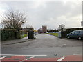
Image Map
Images are licensed for reuse under creativecommons.org/licenses/by-sa/2.0
Notes
- Clicking on the map will re-center to the selected point.
- The higher the marker number, the further away the image location is from the centre of the postcode.
Image Listing (126 Images Found)
Images are licensed for reuse under creativecommons.org/licenses/by-sa/2.0
Image
Details
Distance
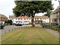
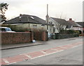
1
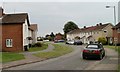
House on the northern arm of Court Farm Road, Llantarnam
Court Farm Road has a roughly rectangular course on the SE side of Brangwyn Avenue. Seen here are houses along a curve on the northern arm of the road.
Image: © Jaggery
Taken: 30 Jul 2010
0.06 miles
2
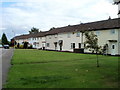
Eastern section of Court Farm Close, Llantarnam
Court Farm Close runs parallel with Llantarnam Road (just out of shot on the left) for about 250 metres.
Image: © Jaggery
Taken: 7 Aug 2010
0.08 miles
3
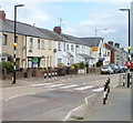
Zebra crossing, Llantarnam Road, Cwmbran
On each side of the crossing, there is a combined Belisha beacon and street light.
The distinctive yellow beacons on black and white poles are named after Leslie Hore-Belisha, the British minister of transport who introduced them in 1934.
Image: © Jaggery
Taken: 7 Aug 2010
0.08 miles
4
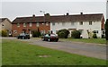
Court Farm Road, Llantarnam
Houses on the north side of the road, viewed from the Brangwyn Avenue end.
Image: © Jaggery
Taken: 30 Jul 2010
0.09 miles
5
A bend in Brangwyn Avenue, Llantarnam
Viewed from the corner of Gainsborough Close. Ahead, Brangwyn Avenue changes direction by about 70 degrees.
Image: © Jaggery
Taken: 30 Jul 2010
0.09 miles
6
Entrance road to the former Llantarnam Comprehensive School, Cwmbran
Now a building site (authorised access only) viewed from Llantarnam Road in late September 2016. The school was placed on special measures after the publication of an unsatisfactory Estyn inspection report in November 2012. The school closed down in July 2015, at the end of the 2014-2015 academic year. The school merged with Fairwater High School on the Fairwater site to create Cwmbran High School which opened in September 2015.
The site of the former Llantarnam Comprehensive School will be used for new housing developments and a new school, Llantarnam Primary School.
Image: © Jaggery
Taken: 22 Sep 2016
0.09 miles
7
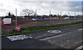
Fenced-off site of a demolished former school, Llantarnam, Cwmbran
This is the site of the demolished former Llantarnam Comprehensive School, viewed from the edge of Llantarnam Road on March 31st 2017. The school was placed on special measures after the publication of an unsatisfactory Estyn inspection report in November 2012. The school closed down in July 2015, at the end of the 2014-2015 academic year. The school merged with Fairwater High School on the Fairwater site to create Cwmbran High School which opened in September 2015.
This site will be used for a new housing development and a new school, Llantarnam Primary School. A nearby notice states that Barratt Homes (South Wales) has been granted planning permission for the erection of 226 new build dwellings and associated infrastructure works, parking, services and landscaping.
Image: © Jaggery
Taken: 31 Mar 2017
0.10 miles
8
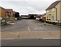
James Prosser Way, Llantarnam, Cwmbran
Recently-built houses on the site of the former Llantarnam Comprehensive school viewed across Llantarnam Road in August 2018. James Prosser Way was named after a former pupil of the school who was a member of 2nd Battalion The Royal Welsh. He trained as a Warrior infantry fighting vehicle driver before being deployed to Afghanistan. He was killed on September 27th 2009 as a result of an explosion while driving his Warrior vehicle in the Musa Qaleh district of Helmand province in Afghanistan.
Image: © Jaggery
Taken: 4 Aug 2018
0.12 miles
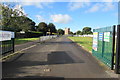
9
Entrance to Llantarnam School
This is the entrance drive. The exit drive is about 50 metres further along Llantarnam Road.
Image: © Jaggery
Taken: 24 Feb 2010
0.12 miles
10
Llantarnam Road bungalows
Located on the SW side of Llantarnam Road, near Llantarnam School.
Image: © Jaggery
Taken: 24 Feb 2010
0.12 miles