IMAGES TAKEN NEAR TO
Pettingale Road, CWMBRAN, NP44 2NY
Introduction
This page details the photographs taken nearby to Pettingale Road, NP44 2NY by members of the Geograph project.
The Geograph project started in 2005 with the aim of publishing, organising and preserving representative images for every square kilometre of Great Britain, Ireland and the Isle of Man.

There are currently over 7.5m images from over14,400 individuals and you can help contribute to the project by visiting https://www.geograph.org.uk
Image Map
Images are licensed for reuse under creativecommons.org/licenses/by-sa/2.0
Notes
- Clicking on the map will re-center to the selected point.
- The higher the marker number, the further away the image location is from the centre of the postcode.
Image Listing (46 Images Found)
Images are licensed for reuse under creativecommons.org/licenses/by-sa/2.0
Image
Details
Distance
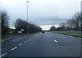
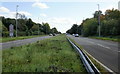
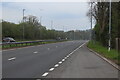
2
Lay-by, Croesyceiliog By-Pass, A4042
Towards roundabout at northern end of by-pass.
Image: © M J Roscoe
Taken: 22 Apr 2023
0.05 miles
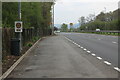
3
Pettingale Road, Croesyceiliog
This is the northern end of Pettingale Road, at the junction with The Highway.
The southern end joins The Highway about 400 metres to the south, having looped around and run parallel to the A4042 (Croesyceiliog Bypass) for most of its length.
Image: © Jaggery
Taken: 8 Oct 2009
0.07 miles
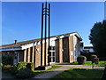
4
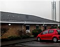
North side of the Mormon Church, Croesyceiliog, Cwmbran
Though often referred to as Mormons, this religious group refer
to themselves as the Church of Jesus Christ of Latter-day Saints.
Image: © Jaggery
Taken: 24 Dec 2023
0.09 miles
5

Welsh name on the Mormon Church, Croesyceiliog, Cwmbran
IESU GRIST (Welsh for Jesus Christ) is on the name sign on the far right here. https://www.geograph.org.uk/photo/1526202
Image: © Jaggery
Taken: 24 Dec 2023
0.09 miles
6
Church of Jesus Christ of Latter Day Saints, Croesyceiliog
Image: © Ruth Sharville
Taken: 12 Mar 2012
0.10 miles
7
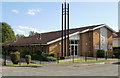
Mormon church, Croesyceiliog
Located on Newport Road, close to the junction with The Highway and Chapel Lane.
Though often referred to as Mormons, this religious group refer to themselves as the Church of Jesus Christ of Latter-day Saints.
Image: © Jaggery
Taken: 8 Oct 2009
0.12 miles
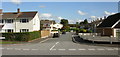
8
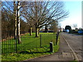
Green in Newport Road, now a cul-de-sac, Croesyceiliog
Image: © Ruth Sharville
Taken: 12 Mar 2012
0.13 miles
9
Croesyceiliog Bypass
The A4042 heading south from the roundabout near Gwent Crematorium, viewed from the small grassy triangle where pedestrians cross the road.
Image: © Jaggery
Taken: 8 Oct 2009
0.13 miles
10
Croesyceiliog By-Pass, A4042
Looking south from lay-by Image on western carriageway.
Image: © M J Roscoe
Taken: 22 Apr 2023
0.14 miles