IMAGES TAKEN NEAR TO
Station Farm, CWMBRAN, NP44 2JW
Introduction
This page details the photographs taken nearby to Station Farm, NP44 2JW by members of the Geograph project.
The Geograph project started in 2005 with the aim of publishing, organising and preserving representative images for every square kilometre of Great Britain, Ireland and the Isle of Man.

There are currently over 7.5m images from over14,400 individuals and you can help contribute to the project by visiting https://www.geograph.org.uk
Image Map
Images are licensed for reuse under creativecommons.org/licenses/by-sa/2.0
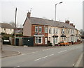
Notes
- Clicking on the map will re-center to the selected point.
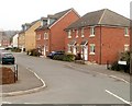
- The higher the marker number, the further away the image location is from the centre of the postcode.
Image Listing (272 Images Found)
Images are licensed for reuse under creativecommons.org/licenses/by-sa/2.0
Image
Details
Distance
1
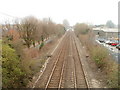
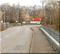
Railway SSE from Station Road bridge, Cwmbran
The view SSE along the Welsh Marches Line. Cwmbran station is just about visible in the hazy distance.
Confusingly, Station Road does not lead to Cwmbran station. The photographer is near the site of the now demolished Lower Pontnewydd railway station, where passenger services were withdrawn in 1958.
Image: © Jaggery
Taken: 28 Mar 2011
0.04 miles
2
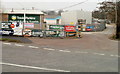
Entrance to Travis Perkins premises, Cwmbran
Viewed across Station Road. Travis Perkins (timber and building supplies) have a UK network of more than 600 branches.
Image: © Jaggery
Taken: 28 Mar 2011
0.04 miles
3
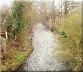
Afon Lwyd, Lower Pontnewydd, Cwmbran
The Afon Lwyd flows away from the corner of Station Road and Stonebridge Park.
Image: © Jaggery
Taken: 28 Mar 2011
0.04 miles
4
Afon Lwyd flows away from Station Road, Cwmbran
Viewed from this http://www.geograph.org.uk/photo/3257792 road bridge.
Image: © Jaggery
Taken: 12 Dec 2012
0.04 miles
5
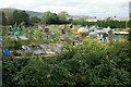
Riverside allotments in Cwmbran
Viewed from Afon Terrace, these allotments are on the bank of a river, the Afon Lwyd.
Image: © Jaggery
Taken: 15 Feb 2015
0.04 miles
6
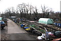
Woodland Road allotments, Cwmbran
The Woodland Road allotments are situated on both sides of Edlogan Way. Their northeast boundary is Afon Terrace and Woodland Road. Their southwest boundary is the Afon Lwyd river.
This is one of 39 allotment sites in Torfaen, where allotments are rented in units of a perch. Torfaen’s 2006 charge per perch was 75 pence. Most allotments in Torfaen are either 5 or 10 perches, so the annual charge was between £8 and £12 per year. This amount included an affiliation fee to the chosen site, membership of The National Society of Allotment and Leisure Gardeners, plus insurance.
Image: © Jaggery
Taken: 8 Oct 2009
0.05 miles
7
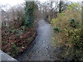
Afon Terrace entrance to Woodland Road allotments, Cwmbran
This entrance is into the NE side of the allotments. http://www.geograph.org.uk/photo/1534922
Image: © Jaggery
Taken: 28 Mar 2011
0.05 miles
8
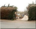
Bend in Station Road, Cwmbran
Looking towards Stonebridge Park houses. http://www.geograph.org.uk/photo/2328965
Image: © Jaggery
Taken: 28 Mar 2011
0.05 miles
9
Afon Terrace, Lower Pontnewydd, Cwmbran
Viewed from the SE end of Station Road. The Afon (river) in question is the Afon Lwyd. The left turn is into Stonebridge Park.
Image: © Jaggery
Taken: 28 Mar 2011
0.05 miles
10
Stonebridge Park houses, Cwmbran
Houses built c2006 viewed from the western edge of Afon Terrace. http://www.geograph.org.uk/photo/2328771
Image: © Jaggery
Taken: 28 Mar 2011
0.05 miles