IMAGES TAKEN NEAR TO
Stonebridge Park, CWMBRAN, NP44 2JL
Introduction
This page details the photographs taken nearby to Stonebridge Park, NP44 2JL by members of the Geograph project.
The Geograph project started in 2005 with the aim of publishing, organising and preserving representative images for every square kilometre of Great Britain, Ireland and the Isle of Man.

There are currently over 7.5m images from over14,400 individuals and you can help contribute to the project by visiting https://www.geograph.org.uk
Image Map
Images are licensed for reuse under creativecommons.org/licenses/by-sa/2.0
Notes
- Clicking on the map will re-center to the selected point.
- The higher the marker number, the further away the image location is from the centre of the postcode.
Image Listing (257 Images Found)
Images are licensed for reuse under creativecommons.org/licenses/by-sa/2.0
Image
Details
Distance
1
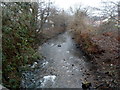
Afon Lwyd flows towards Station Road, Cwmbran
Viewed from this http://www.geograph.org.uk/photo/3257792 road bridge.
Image: © Jaggery
Taken: 12 Dec 2012
0.03 miles
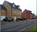
2
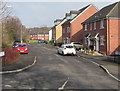
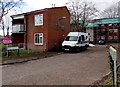
Stonebridge Park, Cwmbran
Viewed across Afon Terrace. Stonebridge Park is a cul-de-sac of about
60 houses built c2006-2007 on the east bank of a river, the Afon Lwyd.
Image: © Jaggery
Taken: 15 Feb 2015
0.03 miles
3
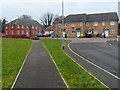
Houses at the far end of Stonebridge Park, Cwmbran
Stonebridge Park is a cul-de-sac of about 60 houses built in c2006-2007 on the east bank of a river,
the Afon Lwyd. Behind the camera, Stonebridge Park connects with Afon Terrace and Station Road.
Image: © Jaggery
Taken: 12 Dec 2012
0.04 miles
4
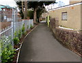
Path on the northwest side of Edlogan Way, Croesyceiliog, Cwmbran
From Edlogan Way towards Stonebridge Park.
Image: © Jaggery
Taken: 7 Mar 2018
0.04 miles
5
Houses on the east side of Stonebridge Park, Cwmbran
Viewed looking in the direction of the junction with Afon Terrace and Station Road. Stonebridge Park is a cul-de-sac of about 60 houses built in c2006-2007 on the east bank of a river, the Afon Lwyd.
Image: © Jaggery
Taken: 12 Dec 2012
0.05 miles
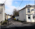
6
Bronllys Place, Croesyceiliog, Cwmbran
On the west side of Edlogan Way.
Image: © Jaggery
Taken: 15 Feb 2015
0.06 miles
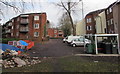
7
Station Road entrance to a business area in Lower Pontnewydd, Cwmbran
The names of the businesses are displayed out of shot on the right. http://www.geograph.org.uk/photo/4548798
Image: © Jaggery
Taken: 15 Feb 2015
0.06 miles
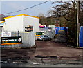
8
Conway Terrace, Cwmbran
Cul-de-sac viewed across Afon Terrace. Canine Corner http://www.geograph.org.uk/photo/4548731 is on the right.
Image: © Jaggery
Taken: 15 Feb 2015
0.06 miles
9
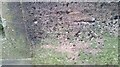
Ordnance Survey Cut Mark
This OS cut mark can be found on the NE parapet of the bridge. It marks a point 63.770m above mean sea level.
Image: © Adrian Dust
Taken: 16 Feb 2021
0.06 miles
10
Bronllys Place, Croesyceiliog, Cwmbran
Viewed from the corner of Edlogan Way. The name sign shows that Bronllys Place is Maes Bronllys in Welsh.
Image: © Jaggery
Taken: 7 Mar 2018
0.06 miles