IMAGES TAKEN NEAR TO
Tewdric Court, CWMBRAN, NP44 2HP
Introduction
This page details the photographs taken nearby to Tewdric Court, NP44 2HP by members of the Geograph project.
The Geograph project started in 2005 with the aim of publishing, organising and preserving representative images for every square kilometre of Great Britain, Ireland and the Isle of Man.

There are currently over 7.5m images from over14,400 individuals and you can help contribute to the project by visiting https://www.geograph.org.uk
Image Map
Images are licensed for reuse under creativecommons.org/licenses/by-sa/2.0
Notes
- Clicking on the map will re-center to the selected point.
- The higher the marker number, the further away the image location is from the centre of the postcode.
Image Listing (99 Images Found)
Images are licensed for reuse under creativecommons.org/licenses/by-sa/2.0
Image
Details
Distance
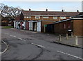
1
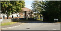
Entrance to Croesyceiliog Community Education Centre
From The Highway.
Image: © Jaggery
Taken: 8 Oct 2009
0.01 miles
2
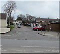
Up Brynhyfryd, Croesyceiliog, Cwmbran
The road named Brynhyfryd ascends from North Road.
Image: © Jaggery
Taken: 27 Feb 2018
0.04 miles
3

Post Room white van, Croesyceiliog, Cwmbran
Text on the van parked outside The Post Room https://www.geograph.org.uk/photo/7677298 in November 2024 includes
"Cafe Takeaway Catering
Corporate & Private
Events Catering
Hog Roasts"
Image: © Jaggery
Taken: 3 Nov 2024
0.04 miles
4
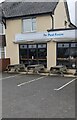
Picnic tables outside The Post Room, Croesyceiliog, Cwmbran
The Post Room is a cafe and takeaway set back from the west side of The Highway.
Image: © Jaggery
Taken: 3 Nov 2024
0.05 miles
5
Ashford Close, Croesyceiliog
Heading away from The Highway towards the junction with Ashford Close North and Ashford Close South. It appears on some maps that the far end of Ashford Close joins with The Plantation, but that is not so. The ends of the two roads are separated by trees.
Image: © Jaggery
Taken: 8 Oct 2009
0.05 miles
6
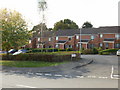
Tewdric Court, Croesyceiliog
The northern part of Tewdric Court, which is located on the western side of The Highway, opposite Ashford Close. The sign below the Tewdric Court sign reads
"Eastern Valley Housing Association
Private Parking Residents Only"
Image: © Jaggery
Taken: 8 Oct 2009
0.06 miles
7
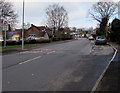
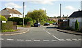
NE along The Highway, Croesyceiliog, Cwmbran
Viewed from opposite the North Road junction.
Image: © Jaggery
Taken: 15 Feb 2015
0.06 miles
8
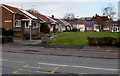
Royal Oak Green, Croesyceiliog, Cwmbran
Bungalows on the corner of North Road and The Highway, viewed in mid February 2015.
There were no rooftop solar panels here in 2011. http://www.geograph.org.uk/photo/2597342
Image: © Jaggery
Taken: 15 Feb 2015
0.07 miles
9
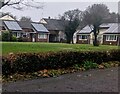
Bungalow rooftop solar panels, Croesyceiliog, Cwmbran
Viewed from The Highway.
Image: © Jaggery
Taken: 24 Dec 2023
0.07 miles
10
Brynhyfryd lockup garages, Croesyceiliog, Cwmbran
Viewed from North Road.
Image: © Jaggery
Taken: 15 Feb 2015
0.07 miles