IMAGES TAKEN NEAR TO
Woodland Road, CWMBRAN, NP44 2DX
Introduction
This page details the photographs taken nearby to Woodland Road, NP44 2DX by members of the Geograph project.
The Geograph project started in 2005 with the aim of publishing, organising and preserving representative images for every square kilometre of Great Britain, Ireland and the Isle of Man.

There are currently over 7.5m images from over14,400 individuals and you can help contribute to the project by visiting https://www.geograph.org.uk
Image Map
Images are licensed for reuse under creativecommons.org/licenses/by-sa/2.0
Notes
- Clicking on the map will re-center to the selected point.
- The higher the marker number, the further away the image location is from the centre of the postcode.
Image Listing (125 Images Found)
Images are licensed for reuse under creativecommons.org/licenses/by-sa/2.0
Image
Details
Distance
1
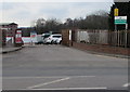
Woodland Road entrance to Croesyceiliog School, Cwmbran
The sign on the right shows that the school name is Ysgol Croesyceiliog in Welsh.
Image: © Jaggery
Taken: 27 Feb 2018
0.01 miles
2
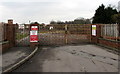
Woodland Road entrance gates, Croesyceiliog School, Cwmbran
The gates are locked today, a Sunday. On school days, in the interest of pupil safety, no unauthorised vehicles
are allowed to enter the school site from 8.30am-8.50am and 3pm-3.20pm. No smoking in this area.
Image: © Jaggery
Taken: 15 Feb 2015
0.01 miles
3
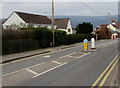
Woodland Road pedestrian refuge, Croesyceiliog, Cwmbran
The refuge lets walkers cross half a road width at a time when traffic is busy.
Image: © Jaggery
Taken: 27 Feb 2018
0.01 miles
4
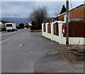
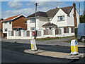
Queen Elizabeth II postbox on a wooden pole, Woodland Road, Croesyceiliog, Cwmbran
Near the Turnpike Road and The Highway T-junction behind the camera.
Image: © Jaggery
Taken: 27 Feb 2018
0.02 miles
5
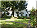
Jim Crow's cottage, Croesyceiliog
Cottage in Jim Crow Square, set back from The Highway near the Woodland Road/Turnpike Road junction.
I don't know who Jim Crow was, but he appears to have been of some importance locally : Jim Crow's Wood is adjacent to Croesyceiliog School. What is certain is that there is no connection with the Jim Crow laws which enforced racial segregation in some parts of the USA between 1876 and 1965.
Image: © Jaggery
Taken: 8 Oct 2009
0.03 miles
6
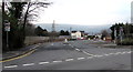
SE end of Woodland Road, Croesyceiliog, Cwmbran
At the junction of Turnpike Road to the left and The Highway to the right.
Image: © Jaggery
Taken: 15 Feb 2015
0.03 miles
7
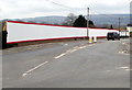
Long red and white fence, Woodland Road, Croesyceiliog, Cwmbran
Viewed in February 2018. The fence covers Croesyceiliog School perimeter railings. Behind the fence, work is in progress on the construction of new school buildings which will replace the existing buildings.
Image: © Jaggery
Taken: 27 Feb 2018
0.04 miles
8
Woodland Road entrance to Croesyceiliog School, Cwmbran
The school website states that Croesyceiliog School is a comprehensive school for pupils and students aged 11-18 years. Under Welsh Assembly Government regulations, the school is defined as a Predominantly English Medium Secondary School. The school was created in 1971 through the merger of a grammar school (opened in 1959) with an adjacent secondary modern school (opened in 1957).
Image: © Jaggery
Taken: 15 Feb 2015
0.04 miles
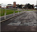
9
Woodland Road houses opposite Croesyceiliog School, Cwmbran
Viewed from the school entrance road. http://www.geograph.org.uk/photo/2599082
Image: © Jaggery
Taken: 13 Sep 2011
0.04 miles
10
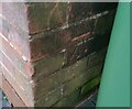
Ordnance Survey Cut Mark
This OS cut mark can be found on No74 Woodland Road. It marks a point 72.171m above mean sea level.
Image: © Adrian Dust
Taken: 16 Feb 2021
0.05 miles