IMAGES TAKEN NEAR TO
Lon Helyg, CWMBRAN, NP44 2BD
Introduction
This page details the photographs taken nearby to Lon Helyg, NP44 2BD by members of the Geograph project.
The Geograph project started in 2005 with the aim of publishing, organising and preserving representative images for every square kilometre of Great Britain, Ireland and the Isle of Man.

There are currently over 7.5m images from over14,400 individuals and you can help contribute to the project by visiting https://www.geograph.org.uk
Image Map
Images are licensed for reuse under creativecommons.org/licenses/by-sa/2.0
Notes
- Clicking on the map will re-center to the selected point.
- The higher the marker number, the further away the image location is from the centre of the postcode.
Image Listing (77 Images Found)
Images are licensed for reuse under creativecommons.org/licenses/by-sa/2.0
Image
Details
Distance
1
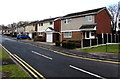
Plantation Drive houses in Croesyceiliog, Cwmbran
Viewed from Turnpike Road. The back gardens of these houses are at the edge of a wood named The Plantation.
Image: © Jaggery
Taken: 15 Feb 2015
0.10 miles
2
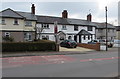
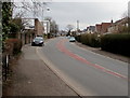
Row of houses alongside The Highway, Croesyceiliog, Cwmbran
South of the North Road junction.
Image: © Jaggery
Taken: 27 Feb 2018
0.10 miles
3
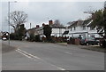
Houses alongside The Highway, Croesyceiliog, Cwmbran
Viewed from the corner of North Road.
Image: © Jaggery
Taken: 27 Feb 2018
0.11 miles
4
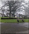
Bench on grass, Croesyceiliog, Cwmbran
On the corner of The Highway and North Road.
Image: © Jaggery
Taken: 24 Dec 2023
0.12 miles
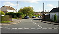
5
Up The Highway, Croesyceiliog, Cwmbran
The Highway ascends towards the North Road junction.
Image: © Jaggery
Taken: 27 Feb 2018
0.12 miles
6
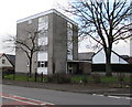
Bron-y-Garth, Croesyceiliog, Cwmbran
Small block of flats viewed across The Highway.
Image: © Jaggery
Taken: 15 Feb 2015
0.12 miles
7

Two Bron Afon vans parked near Bron-y-garth, Croesyceiliog, Cwmbran
Bron-y-garth is a small block of flats on the corner of North Road and The Highway, one of many properties owned by Bron Afon Community Housing, the landlord which was set up specifically to own, manage and improve the housing previously owned by Torfaen County Borough Council.
Image: © Jaggery
Taken: 27 Feb 2018
0.12 miles
8
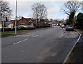
NE along The Highway, Croesyceiliog, Cwmbran
Viewed from opposite the North Road junction.
Image: © Jaggery
Taken: 15 Feb 2015
0.13 miles
9
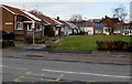
Royal Oak Green, Croesyceiliog, Cwmbran
Bungalows on the corner of North Road and The Highway, viewed in mid February 2015.
There were no rooftop solar panels here in 2011. http://www.geograph.org.uk/photo/2597342
Image: © Jaggery
Taken: 15 Feb 2015
0.13 miles
10
Ashford Close, Croesyceiliog
Heading away from The Highway towards the junction with Ashford Close North and Ashford Close South. It appears on some maps that the far end of Ashford Close joins with The Plantation, but that is not so. The ends of the two roads are separated by trees.
Image: © Jaggery
Taken: 8 Oct 2009
0.13 miles