IMAGES TAKEN NEAR TO
Station Road, CWMBRAN, NP44 1XH
Introduction
This page details the photographs taken nearby to Station Road, NP44 1XH by members of the Geograph project.
The Geograph project started in 2005 with the aim of publishing, organising and preserving representative images for every square kilometre of Great Britain, Ireland and the Isle of Man.

There are currently over 7.5m images from over14,400 individuals and you can help contribute to the project by visiting https://www.geograph.org.uk
Image Map
Images are licensed for reuse under creativecommons.org/licenses/by-sa/2.0
Notes
- Clicking on the map will re-center to the selected point.
- The higher the marker number, the further away the image location is from the centre of the postcode.
Image Listing (262 Images Found)
Images are licensed for reuse under creativecommons.org/licenses/by-sa/2.0
Image
Details
Distance
1
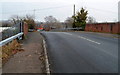
Across Station Road railway bridge, Pontnewydd, Cwmbran
Station Road crosses the Welsh Marches railway line about 300 metres north of Cwmbran railway station. The orange colour in the distance is on a bend here. http://www.geograph.org.uk/photo/3257845
Image: © Jaggery
Taken: 12 Dec 2012
0.02 miles
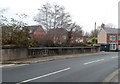
2
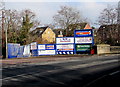
WJW name boards, Station Road, Cwmbran
At the edge of a river, the Afon Lwyd, the name WJW dominates the list of businesses shown - WJW Self Storage and WJW Van & Truck Rental. Other names in view include Travis Perkins Timber & Building Supplies, Winseal Windows, A.C.Jones, DP Fencing and Garden Services and Anne's Hot and Cold Food.
Image: © Jaggery
Taken: 15 Feb 2015
0.02 miles
3
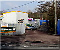
Station Road entrance to a business area in Lower Pontnewydd, Cwmbran
The names of the businesses are displayed out of shot on the right. http://www.geograph.org.uk/photo/4548798
Image: © Jaggery
Taken: 15 Feb 2015
0.02 miles
4
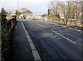
River bridge in Lower Pontnewydd, Cwmbran
Looking from Afon Terrace to Station Road across the bridge over the Afon Lwyd.
Image: © Jaggery
Taken: 15 Feb 2015
0.02 miles
5
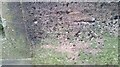
Ordnance Survey Cut Mark
This OS cut mark can be found on the NE parapet of the bridge. It marks a point 63.770m above mean sea level.
Image: © Adrian Dust
Taken: 16 Feb 2021
0.03 miles
6
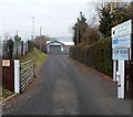
Entrance road to Station Buildings, Cwmbran
Viewed from the edge of Station Road. Confusingly for those who do not know the history of the area, Station Buildings and Station Road are near the site of Lower Pontnewydd railway station, formerly located about 300 metres north of the present-day Cwmbran railway station. Passenger services at Lower Pontnewydd railway station ceased in 1958.
Image: © Jaggery
Taken: 12 Dec 2012
0.03 miles
7
Station Road river bridge, Cwmbran
The bridge carries Station Road over the Afon Lwyd. On the far side of the bridge, the road is named Afon Terrace. The houses behind the trees are in Stonebridge Park.
Image: © Jaggery
Taken: 12 Dec 2012
0.03 miles
8
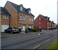
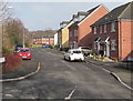
Houses on the east side of Stonebridge Park, Cwmbran
Viewed looking in the direction of the junction with Afon Terrace and Station Road. Stonebridge Park is a cul-de-sac of about 60 houses built in c2006-2007 on the east bank of a river, the Afon Lwyd.
Image: © Jaggery
Taken: 12 Dec 2012
0.04 miles
9
Stonebridge Park, Cwmbran
Viewed across Afon Terrace. Stonebridge Park is a cul-de-sac of about
60 houses built c2006-2007 on the east bank of a river, the Afon Lwyd.
Image: © Jaggery
Taken: 15 Feb 2015
0.04 miles
10
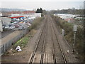
Lower Pontnewydd railway station (site), Gwent
Opened in 1858 by the Pontypool Caerleon & Newport Railway, soon to become part of the Great Western Railway, this station closed to passengers in 1958 and completely in 1965.
View north towards Panteg and Pontypool. No trace appears to remain.
Image: © Nigel Thompson
Taken: 14 Mar 2015
0.05 miles