IMAGES TAKEN NEAR TO
Caldicot Way, CWMBRAN, NP44 1UF
Introduction
This page details the photographs taken nearby to Caldicot Way, NP44 1UF by members of the Geograph project.
The Geograph project started in 2005 with the aim of publishing, organising and preserving representative images for every square kilometre of Great Britain, Ireland and the Isle of Man.

There are currently over 7.5m images from over14,400 individuals and you can help contribute to the project by visiting https://www.geograph.org.uk
Image Map
Images are licensed for reuse under creativecommons.org/licenses/by-sa/2.0
Notes
- Clicking on the map will re-center to the selected point.
- The higher the marker number, the further away the image location is from the centre of the postcode.
Image Listing (152 Images Found)
Images are licensed for reuse under creativecommons.org/licenses/by-sa/2.0
Image
Details
Distance
1
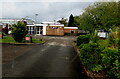
St David's RC Primary & Nursery School, Cwmbran
Located on the south side of Caldicot Way, arguably either at the northern edge of Pontnewydd
or the southern edge of Pontrhydyrun.
Image: © Jaggery
Taken: 24 May 2013
0.01 miles
2
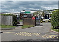
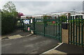
Northeast corner of St David's RC Primary & Nursery School, Cwmbran
Viewed through the main entrance gates https://www.geograph.org.uk/photo/6827885
Image: © Jaggery
Taken: 3 May 2021
0.01 miles
3
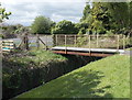
Stream footbridge, Caldicot Way, Cwmbran
The footbridge across a stream, Blaen Bran, connects Caldicot Way
with the west side of St David's RC Primary & Nursery School. http://www.geograph.org.uk/photo/3473919
Image: © Jaggery
Taken: 24 May 2013
0.02 miles
4
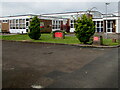
East side of St David's RC Primary School, Cwmbran
Roman Catholic primary school viewed through the main entrance gates https://www.geograph.org.uk/photo/6827885 in May 2021.
Image: © Jaggery
Taken: 3 May 2021
0.02 miles
5
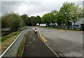
West along Caldicot Way, Cwmbran
One of the roads in Avondale Industrial Estate.
Image: © Jaggery
Taken: 3 May 2021
0.03 miles
6
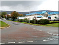
An entrance road to Avondale Industrial Estate, Cwmbran
Viewed across Avondale Road, Caldicot Way heads into Avondale Industrial Estate.
Image: © Jaggery
Taken: 23 Sep 2010
0.03 miles
7
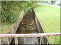
Blaen Bran brook, Caldicot Way, Cwmbran
Looking upstream along a brook on the south side of Caldicot Way. Behind the camera, it flows under Avondale Road and railway lines, emptying into the Afon Lwyd about 70 metres from here.
Blaen Bran began in the high ground of Upper Cwmbran. This is a view http://www.geograph.org.uk/photo/1612076 of it near its source.
Image: © Jaggery
Taken: 23 Sep 2010
0.03 miles
8
South along L?n Nant, Cwmbran
From Caldicot Way, Lôn Nant leads to the main entrance to St David's RC Primary & Nursery School (out of shot on the right ahead).
Image: © Jaggery
Taken: 3 May 2021
0.03 miles
9
Main entrance to St David's RC Primary & Nursery School, Cwmbran
At the southern end of Lôn Nant. The school is closed today, Early Spring Bank Holiday May 3rd 2021.
Image: © Jaggery
Taken: 3 May 2021
0.03 miles
10
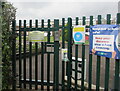
Keep our school safe! Cwmbran
The banner showing "Keep our school safe! Keep your distance. Wear a face covering" is at the main entrance https://www.geograph.org.uk/photo/6827885 to St David's RC Primary & Nursery School in May 2021 during the Coronavirus (COVID-19) pandemic.
Image: © Jaggery
Taken: 3 May 2021
0.03 miles