IMAGES TAKEN NEAR TO
Isca Close, CWMBRAN, NP44 1QN
Introduction
This page details the photographs taken nearby to Isca Close, NP44 1QN by members of the Geograph project.
The Geograph project started in 2005 with the aim of publishing, organising and preserving representative images for every square kilometre of Great Britain, Ireland and the Isle of Man.

There are currently over 7.5m images from over14,400 individuals and you can help contribute to the project by visiting https://www.geograph.org.uk
Image Map
Images are licensed for reuse under creativecommons.org/licenses/by-sa/2.0
Notes
- Clicking on the map will re-center to the selected point.
- The higher the marker number, the further away the image location is from the centre of the postcode.
Image Listing (711 Images Found)
Images are licensed for reuse under creativecommons.org/licenses/by-sa/2.0
Image
Details
Distance
1
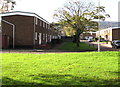
Isca Close, Northville, Cwmbran
From the west side of St David's Road along Isca Close towards Turberville Road.
Image: © Jaggery
Taken: 30 Oct 2017
0.02 miles
2
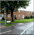
Corner of Trussel Road and St David's Road, Cwmbran
Houses at the SE end of Trussel Road, viewed from the corner of St David's Road.
Image: © Jaggery
Taken: 23 Sep 2010
0.03 miles
3
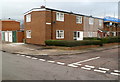
Isca Close, Cwmbran
Houses on the north side of Isca Close, viewed from Turberville Road.
Image: © Jaggery
Taken: 11 Jan 2012
0.03 miles
4
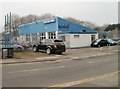
Oaktree Motor Company, Cwmbran
Car sales premises on Somerset Road, next door to the Stagecoach bus depot.
Image: © Jaggery
Taken: 28 Mar 2011
0.03 miles
5
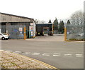
Entrance to Stagecoach bus depot, Cwmbran
Viewed across Somerset Road. Stagecoach are the major operator of bus services in Cwmbran and most of the rest of SE Wales, though they have only a minor presence in the cities of Cardiff and Newport.
The company's offices http://www.geograph.org.uk/photo/1527571 are at the southern edge of the site.
Image: © Jaggery
Taken: 28 Mar 2011
0.03 miles
6
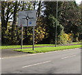
St David's Road directions sign, Northville, Cwmbran
The English/Welsh sign faces southbound traffic on the approach to a roundabout.
Image: © Jaggery
Taken: 30 Oct 2017
0.04 miles
7
Croesyceiliog direction sign, St David's Road, Cwmbran
For Croesyceiliog turn left ahead into Edlogan Way.
Image: © Jaggery
Taken: 30 Oct 2017
0.05 miles
8
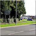
Northville name sign, Cwmbran
Recently installed sign on the corner of St David's Road and Trussel Road
in the Northville area of Cwmbran viewed on October 30th 2017.
The Welsh PENTRE UCHAF https://www.geograph.org.uk/photo/5627779 is on the opposite side.
Image: © Jaggery
Taken: 30 Oct 2017
0.05 miles
9
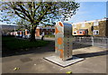
Pentre Uchaf name sign, Northville, Cwmbran
Recently installed sign on the corner of St David's Road and Trussel Road viewed on October 30th 2017.
This is the Welsh name side. The English name side shows NORTHVILLE. https://www.geograph.org.uk/photo/5627778
Image: © Jaggery
Taken: 30 Oct 2017
0.05 miles
10

North along Turberville Road, Northville, Cwmbran
Viewed across Caradoc Road from the edge of Cwmbran Shopping Centre.
Image: © Jaggery
Taken: 14 Apr 2017
0.05 miles