IMAGES TAKEN NEAR TO
Cromwell Place, CWMBRAN, NP44 1NL
Introduction
This page details the photographs taken nearby to Cromwell Place, NP44 1NL by members of the Geograph project.
The Geograph project started in 2005 with the aim of publishing, organising and preserving representative images for every square kilometre of Great Britain, Ireland and the Isle of Man.

There are currently over 7.5m images from over14,400 individuals and you can help contribute to the project by visiting https://www.geograph.org.uk
Image Map
Images are licensed for reuse under creativecommons.org/licenses/by-sa/2.0
Notes
- Clicking on the map will re-center to the selected point.
- The higher the marker number, the further away the image location is from the centre of the postcode.
Image Listing (319 Images Found)
Images are licensed for reuse under creativecommons.org/licenses/by-sa/2.0
Image
Details
Distance
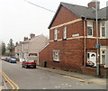
1
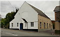
The Well Centre, Pontnewydd
Located on Station Road. Formerly Trinity Presbyterian Church, built in 1903 and rebuilt in 1934. The building is now The Well Centre, the administrative headquarters of The Order of Jacob's Well. Founded by a group of lay and ordained Christians involved in the Christian healing ministry in South Wales, the Order of Jacob's Well now has ministries in England, Scotland and Wales, and is expanding worldwide.
Image: © Jaggery
Taken: 17 Sep 2009
0.02 miles
2
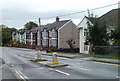
Station Road houses, Cwmbran
Houses on the south side of Station Road. The turning on the right is in to William Street, leading to Porth Mawr Road.
Image: © Jaggery
Taken: 23 Sep 2010
0.02 miles
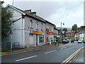
3
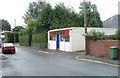
Everything & Anything, Porth Mawr Road, Cwmbran
Located in Urella Stores. Notices on the single-storey premises state
"Scrap gold wanted bought and sold" and
"Selection of new furniture, and household items, always available."
Image: © Jaggery
Taken: 23 Sep 2010
0.02 miles
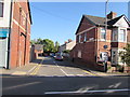
4
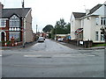
William Street, Cwmbran
Viewed across Station Road. A few metres ahead, William Street leads to Porth Mawr Road.
Image: © Jaggery
Taken: 23 Sep 2010
0.02 miles
5
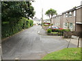
Cromwell Place, Pontnewydd, Cwmbran
Located south of Station Road and east of Cwmbran Drive.
Image: © Jaggery
Taken: 17 Sep 2009
0.05 miles
6
Chinese takeaway and Bangladeshi restaurant, Pontnewydd, Cwmbran
Located on Commercial Street. Nearest the camera is China Palace, Peking and Cantonese take away. Next door is Khan Tandoori Restaurant, serving Bangladeshi cuisine. The small green shop beyond the restaurant is Khan Tandoori's take away and home delivery premises.
At the left edge of the photo, steps descend to the footpath along Cwmbran Drive.
Image: © Jaggery
Taken: 23 Sep 2010
0.05 miles
7

Welcome to Pontnewydd
Station Road approaches the bridge across Cwmbran Drive http://www.geograph.org.uk/photo/2080411 http://www.geograph.org.uk/photo/2080417 and the edge of Pontnewydd.
Image: © Jaggery
Taken: 23 Sep 2010
0.05 miles
8
Harold Street, Pontnewydd, Cwmbran
Houses on the south side of the street, viewed from Chapel Street. At the far end of the street is the perimeter wall of Cwmbran Drive (A4051).
Image: © Jaggery
Taken: 26 Mar 2011
0.05 miles
9
Harold Street, Pontnewydd, Cwmbran
Dead-end street extending for 65 metres from Chapel Street to a wall above the A4051 Cwmbran Drive.
The edge of New Chapel Street Surgery http://www.geograph.org.uk/photo/5144448 is at the far end of the street on the left.
Image: © Jaggery
Taken: 5 Oct 2016
0.05 miles
10
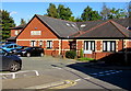
New Chapel Street Surgery, Pontnewydd, Cwmbran
NHS GP (National Health Service General Practitioner (family doctor))
practice at the eastern end of Harold Street, 55 metres from Chapel Street.
Image: © Jaggery
Taken: 5 Oct 2016
0.05 miles