IMAGES TAKEN NEAR TO
Rhodfa'r Hebog, CWMBRAN, NP44 1FJ
Introduction
This page details the photographs taken nearby to Rhodfa'r Hebog, NP44 1FJ by members of the Geograph project.
The Geograph project started in 2005 with the aim of publishing, organising and preserving representative images for every square kilometre of Great Britain, Ireland and the Isle of Man.

There are currently over 7.5m images from over14,400 individuals and you can help contribute to the project by visiting https://www.geograph.org.uk
Image Map
Images are licensed for reuse under creativecommons.org/licenses/by-sa/2.0
Notes
- Clicking on the map will re-center to the selected point.
- The higher the marker number, the further away the image location is from the centre of the postcode.
Image Listing (81 Images Found)
Images are licensed for reuse under creativecommons.org/licenses/by-sa/2.0
Image
Details
Distance
1
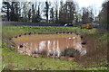
Pond next to roundabout, Cwmbran Drive
The pond is next to a new housing development and its colour indicates it may be a settlement pond for soil washed off the site.
Image: © M J Roscoe
Taken: 12 Apr 2019
0.08 miles
2
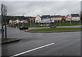
Edlogan Wharf roundabout, Cwmbran Drive, Cwmbran
Viewed in March 2019. The recently-installed roundabout is at the junction leading to new houses in Edlogan Wharf.
Image: © Jaggery
Taken: 6 Mar 2019
0.10 miles
3
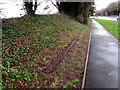
Metal girder alongside Cwmbran Drive, Cwmbran
The length of metal may be a relic of the railway track formerly
on the route now used by this part of the A4051 Cwmbran Drive.
Image: © Jaggery
Taken: 6 Mar 2019
0.11 miles
4
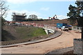
Housing estate under construction
New bridge and new house, part of Edlogan Wharf estate, on greenfield site. The bridge spans a small stream.
Image: © M J Roscoe
Taken: 12 Apr 2019
0.11 miles
5
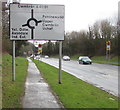
Directions sign alongside Cwmbran Drive, Cwmbran
Facing southbound traffic on the A4051 Cwmbran Drive.
Image: © Jaggery
Taken: 6 Mar 2019
0.11 miles
6
Ffordd Tir Brychiad, Edlogan Wharf estate
Newly completed residential road on new large housing development. Notice lack of road markings and unfinished pavements
Image: © M J Roscoe
Taken: 12 Apr 2019
0.11 miles
7
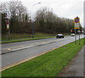
Clearway signs alongside the A4051 Cwmbran Bridge, Cwmbran
Double yellow lines on the camera side end at signs indicating Clearway
(no stopping except in an emergency or traffic jam) for a quarter of a mile.
Image: © Jaggery
Taken: 6 Mar 2019
0.12 miles
8
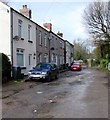
Row of houses, Brook Street, Cwmbran
At the northern end of Brook Street, a dead-end street on the northwest side of Pontrhydyrun Road.
Image: © Jaggery
Taken: 6 Mar 2019
0.12 miles
9
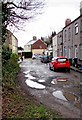
Puddles on Brook Street Cwmbran
Viewed on March 6th 2019.
Image: © Jaggery
Taken: 6 Mar 2019
0.13 miles
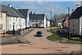
10
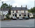
The Terrace pub, Pontrhydyrun, Cwmbran
Pub on the corner of Pontrhydyrun Road and Brook Street. A slight renaming has occurred recently. Today, the name on the red-on-black pub name board is The Terrace. Previously, a white-on-blue name board showed Terrace Inn.
Image: © Jaggery
Taken: 23 Sep 2010
0.13 miles