IMAGES TAKEN NEAR TO
Lle Eirlys, CWMBRAN, NP44 1FE
Introduction
This page details the photographs taken nearby to Lle Eirlys, NP44 1FE by members of the Geograph project.
The Geograph project started in 2005 with the aim of publishing, organising and preserving representative images for every square kilometre of Great Britain, Ireland and the Isle of Man.

There are currently over 7.5m images from over14,400 individuals and you can help contribute to the project by visiting https://www.geograph.org.uk
Image Map
Images are licensed for reuse under creativecommons.org/licenses/by-sa/2.0
Notes
- Clicking on the map will re-center to the selected point.
- The higher the marker number, the further away the image location is from the centre of the postcode.
Image Listing (102 Images Found)
Images are licensed for reuse under creativecommons.org/licenses/by-sa/2.0
Image
Details
Distance
1
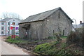
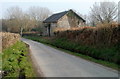
Derelict hay barn, Bevan's Lane
This disused barn will be in the middle of a housing estate, but will be retained (but for how long?) because it contains a bat roost.
Image: © M J Roscoe
Taken: 12 Apr 2019
0.05 miles
2
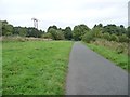
Cycle route along former railway line
Looking north, between Bevan's Lane and Sebastopol.
Image: © Christine Johnstone
Taken: 15 Sep 2013
0.07 miles
3
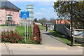
Cycle track north from Bevan's Lane
NCR 492 here is on the course of a dismantled railway now running between housing estates under construction. The alignment of the track appears to have been modified, and the blue sign may be facing the wrong way.
Image: © M J Roscoe
Taken: 12 Apr 2019
0.07 miles
4
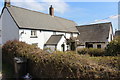
Farm house, Bevan's Lane, Sebastopol
Farm house and attached, apparently disused, outbuildings. All the farm will soon be in the middle of a housing estate.
Image: © M J Roscoe
Taken: 12 Apr 2019
0.07 miles
5
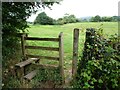
Footpath stile near Tir-brychiad
On the west side of the cycleway along the former railway line.
Image: © Christine Johnstone
Taken: 15 Sep 2013
0.08 miles
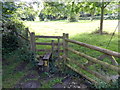
6
Stile next to NCR 492, Sebastopol
Wooden stile with 'footpath closed' sign next to new housing estate.
Image: © M J Roscoe
Taken: 12 Apr 2019
0.09 miles
7
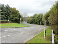
Bevan's Lane, Sebastopol
Bevan's Lane heads away from the Cwmbran Drive / Avondale Road roundabout.
Image: © Jaggery
Taken: 21 Oct 2009
0.09 miles
8
Stile at the southern end of Railway Terrace, Sebastopol
A few metres beyond the last house http://www.geograph.org.uk/photo/3087730 in Railway Terrace, a stile gives access to and from a field.
Image: © Jaggery
Taken: 18 Aug 2012
0.10 miles
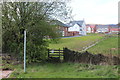
9
Farm building, Bevan's Lane, Sebastopol
Located on the south side of Bevan's Lane.
Image: © Jaggery
Taken: 26 Mar 2011
0.10 miles
10
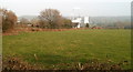
Field bordering Bevan's Lane, Sebastopol
Viewed from the towpath of the disused Monmouthshire & Brecon canal. The line of low hedges on the left marks the course of Bevan's Lane. The distant smoky chimneys are in the Knauf site. http://www.geograph.org.uk/photo/1577012
Image: © Jaggery
Taken: 26 Mar 2011
0.11 miles