IMAGES TAKEN NEAR TO
Stanley Place, CWMBRAN, NP44 1DT
Introduction
This page details the photographs taken nearby to Stanley Place, NP44 1DT by members of the Geograph project.
The Geograph project started in 2005 with the aim of publishing, organising and preserving representative images for every square kilometre of Great Britain, Ireland and the Isle of Man.

There are currently over 7.5m images from over14,400 individuals and you can help contribute to the project by visiting https://www.geograph.org.uk
Image Map
Images are licensed for reuse under creativecommons.org/licenses/by-sa/2.0
Notes
- Clicking on the map will re-center to the selected point.
- The higher the marker number, the further away the image location is from the centre of the postcode.
Image Listing (318 Images Found)
Images are licensed for reuse under creativecommons.org/licenses/by-sa/2.0
Image
Details
Distance
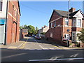
1
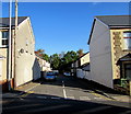
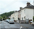
Stanley Place, Pontnewydd, Cwmbran
Dead-end street extending for 60 metres from Chapel Street to a wall and trees above the A4051 Cwmbran Drive.
Image: © Jaggery
Taken: 5 Oct 2016
0.01 miles
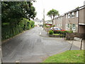
2
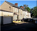
Houses at the eastern end of Stanley Place, Pontnewydd, Cwmbran
60 metres east of Chapel Street, Stanley Place ends at a wall and trees above the A4051 Cwmbran Drive.
Image: © Jaggery
Taken: 5 Oct 2016
0.01 miles
3
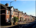
Row of houses, Chapel Street, Pontnewydd, Cwmbran
Extending for 45 metres from Harold Street to Stanley Place.
Image: © Jaggery
Taken: 5 Oct 2016
0.03 miles
4
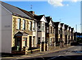
Row of houses, Chapel Street, Pontnewydd, Cwmbran
Extending south for 40 metres from the corner of Stanley Place.
Image: © Jaggery
Taken: 5 Oct 2016
0.04 miles
5
Cromwell Place, Cwmbran
Looking along the SW end of Cromwell Place, towards Wayfield Crescent.
Image: © Jaggery
Taken: 20 Jul 2011
0.04 miles
6
Cromwell Place, Pontnewydd, Cwmbran
Located south of Station Road and east of Cwmbran Drive.
Image: © Jaggery
Taken: 17 Sep 2009
0.04 miles
7
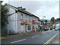
Chinese takeaway and Bangladeshi restaurant, Pontnewydd, Cwmbran
Located on Commercial Street. Nearest the camera is China Palace, Peking and Cantonese take away. Next door is Khan Tandoori Restaurant, serving Bangladeshi cuisine. The small green shop beyond the restaurant is Khan Tandoori's take away and home delivery premises.
At the left edge of the photo, steps descend to the footpath along Cwmbran Drive.
Image: © Jaggery
Taken: 23 Sep 2010
0.04 miles
8

Welcome to Pontnewydd
Station Road approaches the bridge across Cwmbran Drive http://www.geograph.org.uk/photo/2080411 http://www.geograph.org.uk/photo/2080417 and the edge of Pontnewydd.
Image: © Jaggery
Taken: 23 Sep 2010
0.04 miles
9
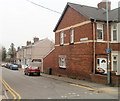
Harold Street, Pontnewydd, Cwmbran
Houses on the south side of the street, viewed from Chapel Street. At the far end of the street is the perimeter wall of Cwmbran Drive (A4051).
Image: © Jaggery
Taken: 26 Mar 2011
0.04 miles
10
Harold Street, Pontnewydd, Cwmbran
Dead-end street extending for 65 metres from Chapel Street to a wall above the A4051 Cwmbran Drive.
The edge of New Chapel Street Surgery http://www.geograph.org.uk/photo/5144448 is at the far end of the street on the left.
Image: © Jaggery
Taken: 5 Oct 2016
0.04 miles