IMAGES TAKEN NEAR TO
Laybourne Close, CWMBRAN, NP44 1DR
Introduction
This page details the photographs taken nearby to Laybourne Close, NP44 1DR by members of the Geograph project.
The Geograph project started in 2005 with the aim of publishing, organising and preserving representative images for every square kilometre of Great Britain, Ireland and the Isle of Man.

There are currently over 7.5m images from over14,400 individuals and you can help contribute to the project by visiting https://www.geograph.org.uk
Image Map
Images are licensed for reuse under creativecommons.org/licenses/by-sa/2.0
Notes
- Clicking on the map will re-center to the selected point.
- The higher the marker number, the further away the image location is from the centre of the postcode.
Image Listing (339 Images Found)
Images are licensed for reuse under creativecommons.org/licenses/by-sa/2.0
Image
Details
Distance
2
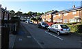
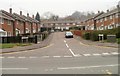
West along Laybourne Close, Pontnewydd, Cwmbran
From the corner of Chapel Street. This part of Laybourne Close is aligned west-east.
The Laybourne Close houses in the background are aligned north-south.
Image: © Jaggery
Taken: 5 Oct 2016
0.02 miles
3
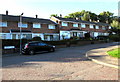
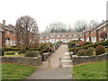
Laybourne Close houses, Pontnewydd, Cwmbran
Laybourne Close is on the west side of Chapel Street.
Image: © Jaggery
Taken: 5 Oct 2016
0.03 miles
4
West along Padarn Place, Pontnewydd, Cwmbran
Padarn Place (Maes Padarn in Welsh) extends from Chapel Street to Laybourne Close.
Image: © Jaggery
Taken: 5 Oct 2016
0.03 miles
5
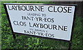
Example of Welsh mutation on a Pontnewydd street name sign, Cwmbran
The bilingual sign is on the corner of Chapel Street and Laybourne Close.
The street known as Pant-yr-Eos in English is also Pant-yr-Eos in Welsh,
but the preposition i (to) causes the P to mutate to B in Welsh.
Image: © Jaggery
Taken: 5 Oct 2016
0.03 miles
6

Ordnance Survey Cut Mark
This OS cut mark can be found on No1 Laybourne Close. It marks a point 72.762m above mean sea level.
Image: © Adrian Dust
Taken: 17 Aug 2020
0.03 miles
7
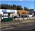
Chapel Street bus stop and shelter, Pontnewydd, Cwmbran
This stop is for buses to the town centre and bus station.
Image: © Jaggery
Taken: 5 Oct 2016
0.03 miles
8
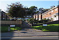
Laybourne Close, Pontnewydd, Cwmbran
Laybourne Close has the shape of the letter T. This view, along the tail of the T, is from Chapel Street.
Image: © Jaggery
Taken: 26 Mar 2011
0.04 miles
9
Padarn Place, Pontnewydd, Cwmbran
Viewed from Chapel Street looking towards Laybourne Close.
Image: © Jaggery
Taken: 26 Mar 2011
0.04 miles
10
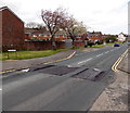
Speed bumps across Chapel Street, Pontnewydd, Cwmbran
Near the Maendy Way junction, opposite houses in Pant-yr-eos.
Image: © Jaggery
Taken: 9 Apr 2014
0.04 miles