IMAGES TAKEN NEAR TO
Maesgwyn, CWMBRAN, NP44 1BQ
Introduction
This page details the photographs taken nearby to Maesgwyn, NP44 1BQ by members of the Geograph project.
The Geograph project started in 2005 with the aim of publishing, organising and preserving representative images for every square kilometre of Great Britain, Ireland and the Isle of Man.

There are currently over 7.5m images from over14,400 individuals and you can help contribute to the project by visiting https://www.geograph.org.uk
Image Map
Images are licensed for reuse under creativecommons.org/licenses/by-sa/2.0
Notes
- Clicking on the map will re-center to the selected point.
- The higher the marker number, the further away the image location is from the centre of the postcode.
Image Listing (124 Images Found)
Images are licensed for reuse under creativecommons.org/licenses/by-sa/2.0
Image
Details
Distance
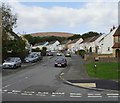
1
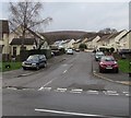
Maesgwyn, Cwmbran
Maesgwyn is a cul-de-sac ascending from the northwest side of Five Locks Road.
Image: © Jaggery
Taken: 6 Mar 2019
0.03 miles
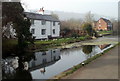
2
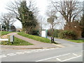
Canal towpath north of Five Locks Road, Cwmbran
The towpath (now a cycle route and footpath) along the disused Monmouthshire & Brecon canal resumes on the north side of Five Locks Road. The road sign at the lower left edge shows Greenfield Close and Five Locks Close.
Image: © Jaggery
Taken: 26 Mar 2011
0.04 miles
3
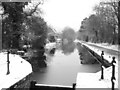
Snow Scene at Five Locks, Pontnewydd
Looking north up the Monmouthshire & Brecon Canal during the snowfall of February 2009.
Image: © Matthew Lane
Taken: 5 Feb 2009
0.04 miles
4
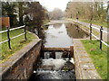
Former canal north of Five Locks Road, Cwmbran
The disused Monmouthshire & Brecon canal, viewed from the edge of a former lock,
now a stepped cascade. http://www.geograph.org.uk/photo/1156826 to a winter view.
Image: © Jaggery
Taken: 26 Mar 2011
0.04 miles
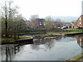
5
Canalside houses, Five Locks, Cwmbran
The houses are located on the east side of Five Locks Close, alongside the disused Monmouthshire & Brecon canal.
Image: © Jaggery
Taken: 26 Mar 2011
0.04 miles
6
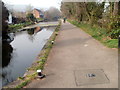
Former canal towpath, Five Locks, Cwmbran
The towpath, now a cycle way and footpath, heads north away from Five Locks Road along the east side of the disused Monmouthshire & Brecon canal. The canal bank is lined with a row of small metal posts formerly used for mooring barges.
Image: © Jaggery
Taken: 26 Mar 2011
0.04 miles
7
Small inlet on disused canal, Five Locks, Cwmbran
The inlet on the disused Monmouthshire & Brecon canal is adjacent to houses in Five Locks Close.
Image: © Jaggery
Taken: 26 Mar 2011
0.04 miles
8
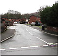
Greenfield Close, Five Locks, Cwmbran
Cul-de-sac on the west side of Five Locks Close in the Five Locks area of northern Cwmbran.
Image: © Jaggery
Taken: 6 Mar 2019
0.06 miles
9
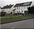
Rooftop solar panels, Five Locks, Cwmbran
On the corner of Five Locks Road and Five Locks Close.
Image: © Jaggery
Taken: 6 Mar 2019
0.07 miles
10
Maesgwyn, Pontnewydd, Cwmbran
Viewed from Five Locks Road.
Image: © Jaggery
Taken: 17 Oct 2009
0.07 miles