IMAGES TAKEN NEAR TO
Lower Mill Field, PONTYPOOL, NP4 0XJ
Introduction
This page details the photographs taken nearby to Lower Mill Field, NP4 0XJ by members of the Geograph project.
The Geograph project started in 2005 with the aim of publishing, organising and preserving representative images for every square kilometre of Great Britain, Ireland and the Isle of Man.

There are currently over 7.5m images from over14,400 individuals and you can help contribute to the project by visiting https://www.geograph.org.uk
Image Map
Images are licensed for reuse under creativecommons.org/licenses/by-sa/2.0
Notes
- Clicking on the map will re-center to the selected point.
- The higher the marker number, the further away the image location is from the centre of the postcode.
Image Listing (186 Images Found)
Images are licensed for reuse under creativecommons.org/licenses/by-sa/2.0
Image
Details
Distance
1
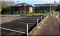
Scaffolding on Tŷ'r Felin, Lower Mill Field, Pontypool
Melin Homes premises encased in scaffolding in late January 2015.
Tŷ'r Felin is near Melin's Tŷ'r Efail office building. http://www.geograph.org.uk/photo/4322866
Image: © Jaggery
Taken: 24 Jan 2015
0.01 miles
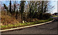
3
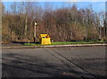
Yellow grit & salt box, Lower Mill Field, Pontypool
The box and a public footpath signpost are alongside the access road to Lower Mill Field from the A472 and A4042.
Image: © Jaggery
Taken: 24 Jan 2015
0.04 miles
4
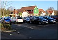
Harvester Pontypool
Restaurant in Lower Mill Field. A Premier Inn http://www.geograph.org.uk/photo/4322280 is nearby.
Image: © Jaggery
Taken: 24 Jan 2015
0.05 miles
5
High pressure gas pipeline marker, Lower Mill Field, Pontypool
Located near the roundabout at the A472 and A4042 junction, the small yellow and white sign marks an underground gas pipeline. A free call phone number is given to be rung before starting any excavation
work here, or in an emergency. All calls are recorded and may be monitored.
Image: © Jaggery
Taken: 24 Jan 2015
0.05 miles
6
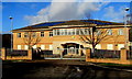
Melin office in Pontypool
The office is Tŷ'r Efail, Lower Mill Field. Created in 2007, Melin Homes is a registered social landlord, a major provider of affordable homes in SE Wales. Melin owns and manages more than 3,500 properties in Blaenau Gwent, Monmouthshire, Torfaen, Newport and Powys.
Image: © Jaggery
Taken: 24 Jan 2015
0.06 miles
7
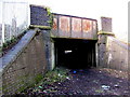
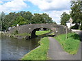
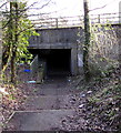
Subway under a railway and the A4042, Pontypool
The track through the 75 metre long subway passes under the Welsh Marches
railway and the A4042, from near Panteg Way on this side, towards Lower Mill.
Image: © Jaggery
Taken: 24 Jan 2015
0.06 miles
8
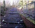
Steps up from a road and railway underpass, Pontypool
Ascending from this http://www.geograph.org.uk/photo/4393698 underpass, steps lead up to a track towards Lower Mill.
Image: © Jaggery
Taken: 24 Jan 2015
0.06 miles
9
Steps down to a road and railway underpass, Pontypool
A public footpath from Lower Mill descends steps to a 75 metre long underpass below the A4042 (on this side) and the Welsh Marches railway. The path beyond the underpass leads to Panteg Way and South Pontypool Industrial Estate.
Image: © Jaggery
Taken: 24 Jan 2015
0.06 miles
10
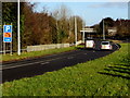
Emergency telephone ahead, A4042, Pontypool
The sign shows that there is an emergency phone in a parking area a third of a mile ahead. Although most motorists have a mobile phone in 2015, there is no guarantee that a signal can be locked onto, especially in many rural areas. Or your phone's batteries may be flat, or you may have left the phone in your other coat at home...
Image: © Jaggery
Taken: 24 Jan 2015
0.06 miles