IMAGES TAKEN NEAR TO
Little Mill, PONTYPOOL, NP4 0UD
Introduction
This page details the photographs taken nearby to NP4 0UD by members of the Geograph project.
The Geograph project started in 2005 with the aim of publishing, organising and preserving representative images for every square kilometre of Great Britain, Ireland and the Isle of Man.

There are currently over 7.5m images from over14,400 individuals and you can help contribute to the project by visiting https://www.geograph.org.uk
Image Map
Images are licensed for reuse under creativecommons.org/licenses/by-sa/2.0
Notes
- Clicking on the map will re-center to the selected point.
- The higher the marker number, the further away the image location is from the centre of the postcode.
Image Listing (18 Images Found)
Images are licensed for reuse under creativecommons.org/licenses/by-sa/2.0
Image
Details
Distance
1
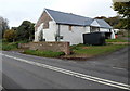
Pant-y-pwdin, Little Mill
Located on the north side of the A472, the former farmhouse is undergoing renovation.
An entry in Kelly's Directory of Monmouthshire 1901 shows Pantapudding, an Anglicised version of Pant-y-pwdin
Image: © Jaggery
Taken: 26 Oct 2012
0.00 miles
2
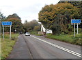
Eastern boundary of Little Mill
The A472 from Usk reaches the Monmouthshire village of Little Mill.
The western boundary signs http://www.geograph.org.uk/photo/3196826 for Monkswood are on the back of the Little Mill signs.
Image: © Jaggery
Taken: 26 Oct 2012
0.02 miles
3
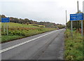
Western boundary of Monkswood
The A472 towards Usk passes from Little Mill to Monkswood.
The Little Mill boundary signs http://www.geograph.org.uk/photo/3196824 are on the back of the Monkswood signs.
Image: © Jaggery
Taken: 26 Oct 2012
0.05 miles
5
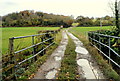
Access lane to New House Farm south of Little Mill
Viewed from the A472, the main road through Little Mill. The farm is about a kilometre ahead.
The railings are at the edge of a small bridge over Berthin Brook, a tributary of the River Usk.
Image: © Jaggery
Taken: 26 Oct 2012
0.14 miles
6
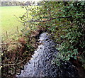
Berthin Brook, Little Mill
Viewed from the bridge shown here. http://www.geograph.org.uk/photo/3196888
Berthin Brook is a tributary of the River Usk.
Image: © Jaggery
Taken: 26 Oct 2012
0.14 miles
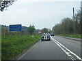
7
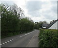
Towards a bend in the A472 beyond Little Mill, Monmouthshire
Ahead for Monkswood and Usk.
Image: © Jaggery
Taken: 23 May 2021
0.15 miles
9
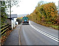
Road cleaning vehicle, Little Mill
A Monmouthshire County Council vehicle is cleaning the surface of the A472, the main road through Little Mill. An occasional queue of traffic briefly built up behind the vehicle, until an opportunity to overtake arose.
Image: © Jaggery
Taken: 26 Oct 2012
0.17 miles
10
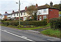
Alexandra Terrace, Monkswood
Alexandra Terrace is a row of 5 houses on the north side of the A472, the main road through Monkswood. At the left edge of the view are 2 of 8 semi-detached houses in Alexandra Place. http://www.geograph.org.uk/photo/3196785
Image: © Jaggery
Taken: 26 Oct 2012
0.20 miles