IMAGES TAKEN NEAR TO
Glascoed, PONTYPOOL, NP4 0TZ
Introduction
This page details the photographs taken nearby to NP4 0TZ by members of the Geograph project.
The Geograph project started in 2005 with the aim of publishing, organising and preserving representative images for every square kilometre of Great Britain, Ireland and the Isle of Man.

There are currently over 7.5m images from over14,400 individuals and you can help contribute to the project by visiting https://www.geograph.org.uk
Image Map
Images are licensed for reuse under creativecommons.org/licenses/by-sa/2.0
Notes
- Clicking on the map will re-center to the selected point.
- The higher the marker number, the further away the image location is from the centre of the postcode.
Image Listing (26 Images Found)
Images are licensed for reuse under creativecommons.org/licenses/by-sa/2.0
Image
Details
Distance
1
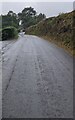
Into Glascoed, Monmouthshire
The unclassified road from the A472 viewed
from near a Glascoed boundary sign. https://www.geograph.org.uk/photo/6994145
Image: © Jaggery
Taken: 17 Oct 2021
0.10 miles
2
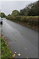
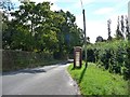
NNW along Wern Lane, Glascoed
Viewed from near this https://www.geograph.org.uk/photo/6994436 former red phonebox.
Image: © Jaggery
Taken: 17 Oct 2021
0.10 miles
3
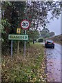
Glascoed boundary sign, Monmouthshire
At the point where the National Speed Limit drops to 30mph.
Image: © Jaggery
Taken: 17 Oct 2021
0.12 miles
4
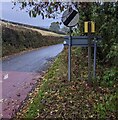
National Speed Limit sign at the edge of Glascoed, Monmouthshire
Marking the end of the 30mph speed limit. Ahead for the A472.
Image: © Jaggery
Taken: 17 Oct 2021
0.12 miles
5
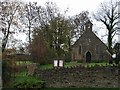
St. Michael's Church, Glascoed
Image: © Jennifer Luther Thomas
Taken: 17 Nov 2006
0.12 miles
6
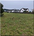
White houses, Church Lane, Glascoed, Monmouthshire
Viewed across St Michael's churchyard.
Image: © Jaggery
Taken: 17 Oct 2021
0.13 miles
7
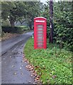
Former telephone box, Wern Lane, Glascoed
Viewed in October 2021. The phone equipment has been removed, leaving an empty red box with GLASCOED on a panel at the top of the box.
Image: © Jaggery
Taken: 17 Oct 2021
0.14 miles
8
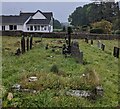
Churchyard gravestones, Glascoed, Monmouthshire
St Michael's Church https://www.geograph.org.uk/photo/6994216 is behind the camera.
Image: © Jaggery
Taken: 17 Oct 2021
0.14 miles
9
Phone box on Wern Lane, Glascoed
Probably not in use.
Image: © Christine Johnstone
Taken: 13 Sep 2013
0.14 miles
10
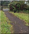
Path from church to Church Lane, Glascoed, Monmouthshire
Descending from St Michael's Church https://www.geograph.org.uk/photo/6994216 in the Church in Wales Diocese of Monmouth.
Image: © Jaggery
Taken: 17 Oct 2021
0.15 miles