IMAGES TAKEN NEAR TO
Pontyvelin Lane, PONTYPOOL, NP4 0TN
Introduction
This page details the photographs taken nearby to Pontyvelin Lane, NP4 0TN by members of the Geograph project.
The Geograph project started in 2005 with the aim of publishing, organising and preserving representative images for every square kilometre of Great Britain, Ireland and the Isle of Man.

There are currently over 7.5m images from over14,400 individuals and you can help contribute to the project by visiting https://www.geograph.org.uk
Image Map
Images are licensed for reuse under creativecommons.org/licenses/by-sa/2.0
Notes
- Clicking on the map will re-center to the selected point.
- The higher the marker number, the further away the image location is from the centre of the postcode.
Image Listing (75 Images Found)
Images are licensed for reuse under creativecommons.org/licenses/by-sa/2.0
Image
Details
Distance
1
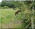
Donkeys grazing in a Lower New Inn field, Pontypool
Viewed from a lane on the west side of Lancaster Road. A donkey foal is alongside the donkey furthest from the camera.
Image: © Jaggery
Taken: 23 Jun 2011
0.06 miles
2
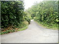
Lane to Lancaster Road, Lower New Inn, Pontypool
A lane crossroads is viewed from the eastern end http://www.geograph.org.uk/photo/2475118 of a track from a footbridge http://www.geograph.org.uk/photo/2475103 over the Afon Lwyd. The lane ahead leads to Lancaster Road. In the foreground is Pont-y-felin Lane.
Image: © Jaggery
Taken: 23 Jun 2011
0.06 miles
3
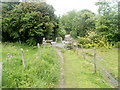
Lower New Inn end of a track from the Afon Lwyd, Pontypool
A 110-metre long track from a footbridge http://www.geograph.org.uk/photo/2475103 over the Afon Lwyd ends at a metal barrier at the edge of Lower New Inn. A blue label on the barrier shows that it was made by Fearn Truck Bodies Ltd, Rotherham, South Yorkshire.
Image: © Jaggery
Taken: 23 Jun 2011
0.06 miles
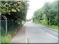
4
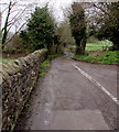
West along Lancaster Road, Lower New Inn
Towards Pont-y-felin Lane.
Image: © Jaggery
Taken: 12 Apr 2018
0.10 miles
5
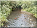
Afon Lwyd upstream, Pont-y-felin Road, Pontypool
The Afon Lwyd flows towards a footbridge http://www.geograph.org.uk/photo/2475103 connecting Pont-y-felin Road with a track to Lower New Inn.
Image: © Jaggery
Taken: 23 Jun 2011
0.11 miles
6
Looking north along Pont-y-felin Road, Pontypool
The road here runs along the perimeter of Pont-y-felin Industrial Estate, the edge of which is protected by a fenced topped with barbed wire.
Image: © Jaggery
Taken: 23 Jun 2011
0.11 miles
7
Pont-y-felin Lane, Lower New Inn, Pontypool
The view SSE along Pont-y-felin Lane from a metal barrier http://www.geograph.org.uk/photo/2475118 at the eastern end of a track from Pont-y-felin Road and the Afon Lwyd.
Image: © Jaggery
Taken: 23 Jun 2011
0.12 miles
8
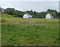
Field and houses, Pont-y-felin Lane, Pontypool
The view south from a lane leading to Lancaster Road, Lower New Inn. The houses are on Pont-y-felin Lane.
Image: © Jaggery
Taken: 23 Jun 2011
0.12 miles
9
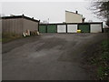
Lancaster Road lockup garages, Lower New Inn
On the north side of Lancaster Road at the southern edge of Monmouth Close.
Image: © Jaggery
Taken: 12 Apr 2018
0.12 miles
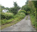
10
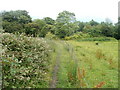
Track from Pont-y-felin Road to Lower New Inn, Pontypool
The view east along a track from a footbridge http://www.geograph.org.uk/photo/2475103 over the Afon Lwyd. On the left side of the track is a large clump of brambles.
Image: © Jaggery
Taken: 23 Jun 2011
0.12 miles