IMAGES TAKEN NEAR TO
Polo Grounds, PONTYPOOL, NP4 0ST
Introduction
This page details the photographs taken nearby to Polo Grounds, NP4 0ST by members of the Geograph project.
The Geograph project started in 2005 with the aim of publishing, organising and preserving representative images for every square kilometre of Great Britain, Ireland and the Isle of Man.

There are currently over 7.5m images from over14,400 individuals and you can help contribute to the project by visiting https://www.geograph.org.uk
Image Map
Images are licensed for reuse under creativecommons.org/licenses/by-sa/2.0
Notes
- Clicking on the map will re-center to the selected point.
- The higher the marker number, the further away the image location is from the centre of the postcode.
Image Listing (156 Images Found)
Images are licensed for reuse under creativecommons.org/licenses/by-sa/2.0
Image
Details
Distance
1
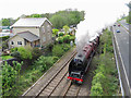
The Duchess near Pontypool & New Inn
LMS Duchess-class 4-6-2 No. 6233 'Duchess of Sutherland' approaches Pontypool & New Inn station on Day 3 of the Railway Touring Company's Great Britain XII tour. This leg was from Taunton to Preston.
Image: © Gareth James
Taken: 29 Apr 2019
0.01 miles
2
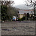
Road into Polo Ground Industrial Estate, New Inn
Descending from The Highway, the main road through New Inn.
Image: © Jaggery
Taken: 11 Apr 2018
0.01 miles
3
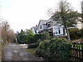
The Avenue, New Inn
Houses on the south side of The Avenue, viewed from near the junction with The Highway.
The road surface of the single-track The Avenue is poorly maintained, and is more like a lane rather than a suburban avenue.
Image: © Jaggery
Taken: 17 Jan 2010
0.01 miles
4

The Highway approaching Ruth Road, New Inn
Looking southeastwards along The Highway as it bends past the junction on the left for Ruth Road. The pavements have patchy icy remnants of recent snow.
Image: © Jaggery
Taken: 17 Jan 2010
0.01 miles
5
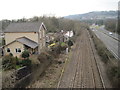
Pontypool Road railway station (site), Gwent
Opened in 1854 by the Newport Abergavenny and Hereford Railway, later part of the Great Western Railway, this station closed in 1909 when it was replaced by a larger facility of the same name, some 300m behind the camera position. That second station is still in business, but was later called Pontypool & New Inn - see Image
View south towards Panteg and Newport. The original line turned right here via Pontypool Clarence Street - all later obliterated by roads.
Image: © Nigel Thompson
Taken: 14 Mar 2015
0.02 miles
6

Two plaques on The Highway road and railway bridge, New Inn
Located here. https://www.geograph.org.uk/photo/5735121 The upper plaque records the opening of the New Inn bypass, Pontypool, on Monday June 14th 1982.
Image: © Jaggery
Taken: 11 Apr 2018
0.03 miles
7
Plaques on the side of The Highway road and railway bridge, New Inn
One of the plaques https://www.geograph.org.uk/photo/5735115 records the opening of the New Inn bypass on Monday June 14th 1982.
Image: © Jaggery
Taken: 11 Apr 2018
0.03 miles
8
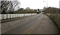
Across The Highway railway bridge, New Inn
The bridge carries The Highway over the A4042 and the Welsh Marches railway near Pontypool & New Inn station. The red and white station name sign https://www.geograph.org.uk/photo/5735083 is at the far end of the bridge on the left side of the road.
Image: © Jaggery
Taken: 11 Apr 2018
0.03 miles
9
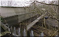
North side of The Highway road and railway bridge, New Inn
The bridge carries The Highway, the main road through New Inn, over the A4042 and railway lines near Pontypool & New Inn station.
Image: © Jaggery
Taken: 11 Apr 2018
0.03 miles
10
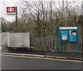
Pontypool & New Inn railway station name sign and information board
Alongside the station approach road at the corner of The Highway.
Image: © Jaggery
Taken: 11 Apr 2018
0.03 miles