IMAGES TAKEN NEAR TO
Monmouth Close, PONTYPOOL, NP4 0PB
Introduction
This page details the photographs taken nearby to Monmouth Close, NP4 0PB by members of the Geograph project.
The Geograph project started in 2005 with the aim of publishing, organising and preserving representative images for every square kilometre of Great Britain, Ireland and the Isle of Man.

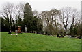
There are currently over 7.5m images from over14,400 individuals and you can help contribute to the project by visiting https://www.geograph.org.uk
Image Map
Images are licensed for reuse under creativecommons.org/licenses/by-sa/2.0
Notes
- Clicking on the map will re-center to the selected point.
- The higher the marker number, the further away the image location is from the centre of the postcode.
Image Listing (123 Images Found)
Images are licensed for reuse under creativecommons.org/licenses/by-sa/2.0
Image
Details
Distance
1
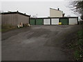
Lancaster Road lockup garages, Lower New Inn
On the north side of Lancaster Road at the southern edge of Monmouth Close.
Image: © Jaggery
Taken: 12 Apr 2018
0.02 miles
2
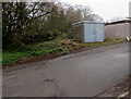
Lower New Inn electricity substation
Located on the north side of Lancaster Road near lockup garages, the cabinet is a Western Power Distribution electricity substation, identifier LOWER NEW INN S/S 536746.
Image: © Jaggery
Taken: 12 Apr 2018
0.03 miles
3
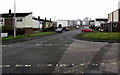
North along Lancaster Road, Lower New Inn
The sign on the left shows that Lancaster Road ahead leads to Monmouth Close.
Image: © Jaggery
Taken: 12 Apr 2018
0.04 miles
4
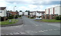
Northern side of Lancaster Road, Lower New Inn, Pontypool
The sign on the left shows 'Lancaster Road leading to Monmouth Close'. The turning for Monmouth Close is about halfway along, on the left.
Image: © Jaggery
Taken: 23 Jun 2011
0.05 miles
5
New Inn Congregational churchyard, Lower New Inn
On the south side of Lancaster Road and the west side of the church. https://www.geograph.org.uk/photo/5737572
Image: © Jaggery
Taken: 12 Apr 2018
0.05 miles
6

Maid by Danielle van, Lancaster Road, Lower New Inn
Text on the side of the van shows ● Domestic Cleaning ● Deep Cleans ● Contract Cleaning.
Image: © Jaggery
Taken: 12 Apr 2018
0.05 miles
7
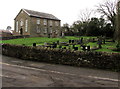
Church and churchyard in Lower New Inn
The west side of New Inn Congregational Church, the 1883 rebuild of the 1710 original.
Image: © Jaggery
Taken: 12 Apr 2018
0.06 miles
8

Entrance to New Inn Congregational Church, Lower New Inn
From Lancaster Road. The church is the 1883 rebuild of the 1710 original.
Image: © Jaggery
Taken: 12 Apr 2018
0.06 miles
9
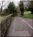
West along Lancaster Road, Lower New Inn
Towards Pont-y-felin Lane.
Image: © Jaggery
Taken: 12 Apr 2018
0.06 miles
10
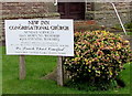
Information board outside New Inn Congregational Church, Lower New Inn
Located here https://www.geograph.org.uk/photo/5737582 the board shows that in April 2018, Sunday Worship is at 11am and 6pm.
Weekday meetings as announced are held in the Sunday School hall https://www.geograph.org.uk/photo/5737651 in Clairwain, New Inn.
Image: © Jaggery
Taken: 12 Apr 2018
0.06 miles