IMAGES TAKEN NEAR TO
Mamhilad, PONTYPOOL, NP4 0JG
Introduction
This page details the photographs taken nearby to NP4 0JG by members of the Geograph project.
The Geograph project started in 2005 with the aim of publishing, organising and preserving representative images for every square kilometre of Great Britain, Ireland and the Isle of Man.

There are currently over 7.5m images from over14,400 individuals and you can help contribute to the project by visiting https://www.geograph.org.uk
Image Map
Images are licensed for reuse under creativecommons.org/licenses/by-sa/2.0
Notes
- Clicking on the map will re-center to the selected point.
- The higher the marker number, the further away the image location is from the centre of the postcode.
Image Listing (55 Images Found)
Images are licensed for reuse under creativecommons.org/licenses/by-sa/2.0
Image
Details
Distance
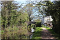
1
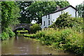
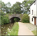
House by bridge No. 65 on the Monmouthshire and Brecon Canal
Image: © David Martin
Taken: 18 Jul 2017
0.02 miles
2
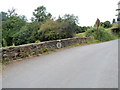
National Park boundary on a canal bridge north of Mamhilad
A rather faded Brecon Beacons National Park boundary marker is on the western wall of bridge 65 http://www.geograph.org.uk/photo/3046541 carrying Old Abergavenny Road over the Monmouthshire and Brecon Canal. The national park begins on the far side of the marker.
Image: © Jaggery
Taken: 20 Jul 2012
0.02 miles
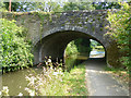
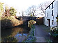
3
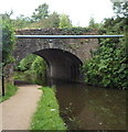
Bridge 65 over the Monmouthshire and Brecon Canal north of Mamhilad
The bridge carries Old Abergavenny Road over the canal.
Image: © Jaggery
Taken: 20 Jul 2012
0.02 miles
4
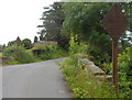
Across canal bridge 65 north of Mamhilad
Old Abergavenny Road crosses the Monmouthshire and Brecon Canal over this http://www.geograph.org.uk/photo/3046541 bridge.
The rusty lozenge-shaped signs, one at each end of the bridge, show a five ton weight limit across the bridge. But the signs are hardly legible and there are no modern-day weight restriction signs on the approaches to the bridge, so perhaps the stone bridge has been strengthened since the old signs were erected.
Image: © Jaggery
Taken: 20 Jul 2012
0.02 miles
5
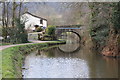
Western side of canal bridge 65, north of Mamhilad
A view along the Monmouthshire and Brecon Canal towards bridge 65 which carries
Old Abergavenny Road. The house is the aptly-named Canal House.
Image: © Jaggery
Taken: 20 Jul 2012
0.02 miles
6
Bridge 65, Monmouthshire and Brecon Canal
Bridge 65 carries a country road over the Monmouthshire and Brecon Canal.
Image: © Philip Halling
Taken: 12 Apr 2013
0.03 miles
7
Old Abergavenny Road bridge over Monmouthshire and Brecon Canal
Image: © David Smith
Taken: 29 Sep 2021
0.03 miles
8
Bridge no.65, Monmouthshire and Brecon Canal
The canal here is the boundary to the Brecon Beacons National Park, the left bank being in the National Park.
See http://www.geograph.org.uk/photo/3046541 for the other side of the bridge.
Image: © Robin Drayton
Taken: 6 Jul 2018
0.03 miles
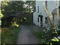
9
Western approach to Bridge 65, Mon & Brec Canal
The bridge carries the Old Abergavenny Road. The tow path is part of NCR 49.
Image: © M J Roscoe
Taken: 20 Apr 2019
0.03 miles
10
"Bridge 65" on the Monmouthshire and Brecon Canal
Image: © Ruth Sharville
Taken: 18 Jan 2015
0.03 miles