IMAGES TAKEN NEAR TO
Abergavenny Road, PONTYPOOL, NP4 0AD
Introduction
This page details the photographs taken nearby to Abergavenny Road, NP4 0AD by members of the Geograph project.
The Geograph project started in 2005 with the aim of publishing, organising and preserving representative images for every square kilometre of Great Britain, Ireland and the Isle of Man.

There are currently over 7.5m images from over14,400 individuals and you can help contribute to the project by visiting https://www.geograph.org.uk
Image Map
Images are licensed for reuse under creativecommons.org/licenses/by-sa/2.0
Notes
- Clicking on the map will re-center to the selected point.
- The higher the marker number, the further away the image location is from the centre of the postcode.
Image Listing (16 Images Found)
Images are licensed for reuse under creativecommons.org/licenses/by-sa/2.0
Image
Details
Distance
1
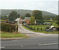
Gelli Farm between Penperlleni and Llanover
Viewed across the A4042. Notices on the gate show that fresh eggs (including duck eggs), potatoes and runner beans can be bought in the farm.
Image: © Jaggery
Taken: 22 Sep 2011
0.01 miles
2
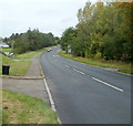
Pavement at last! near Gelli Farm
A mundane subject for a photograph, perhaps, but this pavement was the first since Penperlleni, about a kilometre to the south. Along that section of the busy A4042 there is no provision for walkers, who need to be very circumspect, either using narrow fringes of vegetation, or the roadway.
In the middle distance is the left turn into Gelli Farm. http://www.geograph.org.uk/photo/2614101
Image: © Jaggery
Taken: 22 Sep 2011
0.01 miles
3
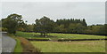
Sheep in a field on the east side of the A4042
Located north of Penperlleni and south of Llanover. Half the sheep are staring at the human being with a camera while the other half continue to graze.
Image: © Jaggery
Taken: 22 Sep 2011
0.08 miles
5
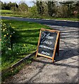
Please Leave RESPECTFULLY, Goytre
In April 2022 the blackboard is on the exit road from The Cedars to the A4042 in rural Monmouthshire.
Image: © Jaggery
Taken: 17 Apr 2022
0.10 miles
6

The Cedars direction sign, Goytre
Facing the A4042 in rural Monmouthshire in April 2022.
Image: © Jaggery
Taken: 17 Apr 2022
0.10 miles
7
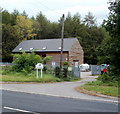
World Wide Sires UK, Goytre
Set back from the east side of the A4042, The Cedars is the premises of
cattle-breeding company World Wide Sires UK.
Image: © Jaggery
Taken: 22 Sep 2011
0.12 miles
8
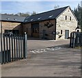
Baffle Culture, The Cedars, Goytre
Coffee shop located in Baffle Haus set back from the A4042 viewed in April 2022.
A September 2018 Google Street View shows Select Security Showroom here.
Image: © Jaggery
Taken: 17 Apr 2022
0.12 miles
9
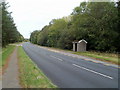
Goytre bus shelter
Located alongside the A4042 on the Abergavenny to Pontypool route.
Image: © Jaggery
Taken: 22 Sep 2011
0.12 miles
10
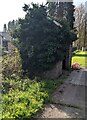
Ivy-clad bus shelter, Goytre, Monmouthshire
The shelter on the east side of the A4042 is alongside a stop for southbound buses.
Image: © Jaggery
Taken: 17 Apr 2022
0.12 miles