IMAGES TAKEN NEAR TO
Swallow Drive, CALDICOT, NP26 5RD
Introduction
This page details the photographs taken nearby to Swallow Drive, NP26 5RD by members of the Geograph project.
The Geograph project started in 2005 with the aim of publishing, organising and preserving representative images for every square kilometre of Great Britain, Ireland and the Isle of Man.

There are currently over 7.5m images from over14,400 individuals and you can help contribute to the project by visiting https://www.geograph.org.uk
Image Map
Images are licensed for reuse under creativecommons.org/licenses/by-sa/2.0
Notes
- Clicking on the map will re-center to the selected point.
- The higher the marker number, the further away the image location is from the centre of the postcode.
Image Listing (37 Images Found)
Images are licensed for reuse under creativecommons.org/licenses/by-sa/2.0
Image
Details
Distance
1
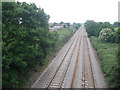
Main line to Paddington, near Caldicot
Looking east.
Image: © Roger Cornfoot
Taken: 6 Jun 2009
0.07 miles
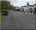
2

Nightingale Close, Caldicot
Viewed across Mill Lane. The bilingual name sign shows that eos is Welsh for nightingale.
Image: © Jaggery
Taken: 11 May 2014
0.08 miles
3
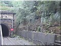
View from a Bristol-Cardiff train - Severn Tunnel entrance, Welsh side
Image: © Nigel Thompson
Taken: 14 Aug 2015
0.09 miles
4

Kingfisher Close bungalows, Caldicot
On the south side of Mill Lane.
Image: © Jaggery
Taken: 11 May 2014
0.10 miles
5
Eagle Close, Caldicot
Viewed across Mill Lane. Eagle Close leads to Falcon Close.
Image: © Jaggery
Taken: 11 May 2014
0.10 miles
6

North side of Durand Primary School, Caldicot
Viewed from a path near Linnet Road. The school entrance is on the far side, from Alianore Road.
Image: © Jaggery
Taken: 11 May 2014
0.11 miles
7
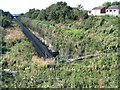
Western end of the Severn Tunnel
Hidden away behind fences and dense vegetation in a residential area, the deep cut Paddington line disappears on its way under the Severn River, to emerge here: Image
Image: © Nigel Davies
Taken: 26 Sep 2007
0.11 miles
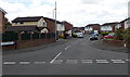
8
Traffic calming on Mill Lane, Caldicot
For a couple of metres, the roadway has been narrowed to less than the width of two cars.
Vehicles travelling away from the camera have priority. The dark red box is for dog waste.
Image: © Jaggery
Taken: 11 May 2014
0.12 miles
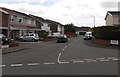
9
Plover Crescent, Caldicot
Cul-de-sac on the south side of Mill Lane.
Image: © Jaggery
Taken: 11 May 2014
0.13 miles
10

Curlew Avenue, Caldicot
Viewed across Mill Lane, along Curlew Avenue, towards Linnet Road.
Image: © Jaggery
Taken: 11 May 2014
0.13 miles