IMAGES TAKEN NEAR TO
Oakley Way, CALDICOT, NP26 4EA
Introduction
This page details the photographs taken nearby to Oakley Way, NP26 4EA by members of the Geograph project.
The Geograph project started in 2005 with the aim of publishing, organising and preserving representative images for every square kilometre of Great Britain, Ireland and the Isle of Man.

There are currently over 7.5m images from over14,400 individuals and you can help contribute to the project by visiting https://www.geograph.org.uk
Image Map
Images are licensed for reuse under creativecommons.org/licenses/by-sa/2.0
Notes
- Clicking on the map will re-center to the selected point.
- The higher the marker number, the further away the image location is from the centre of the postcode.
Image Listing (11 Images Found)
Images are licensed for reuse under creativecommons.org/licenses/by-sa/2.0
Image
Details
Distance
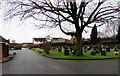
2
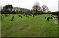
Northeast end of Dewstow Cemetery, Caldicot
Measuring 150 metres by 50 metres, the cemetery occupies a site between Dewstow Road and Oakley Close.
A Caldicot Town Council notice on a board in the cemetery states that this a Lawn Cemetery - no planting of any kind is permitted at any time.
Image: © Jaggery
Taken: 24 Jan 2016
0.12 miles
3
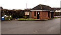
Brick building and noticeboard in Dewstow Cemetery, Caldicot
The building is a shelter with benches, located near Dewstow Road.
The noticeboard displays three Caldicot Town Council notices in January 2016.
One of them states that this a Lawn Cemetery - no planting of any kind is permitted at any time.
Image: © Jaggery
Taken: 24 Jan 2016
0.16 miles
4
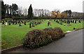
Dewstow Cemetery, Caldicot
Viewed from the Dewstow Road entrance. A Caldicot Town Council notice on a board in the cemetery
states that this a Lawn Cemetery - no planting of any kind is permitted at any time.
Image: © Jaggery
Taken: 24 Jan 2016
0.16 miles
5
Southwest side of Dewstow Cemetery, Caldicot
The road leads to the exit into Dewstow Road.
Image: © Jaggery
Taken: 24 Jan 2016
0.20 miles
6
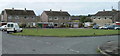
Willow Close, Caldicot
Willow Close is a short cul-de-sac on the west side of Sandy Lane. Houses at the end of the close are arranged along the edge of a rectangle. This view is of houses on the SW side of the rectangle.
Image: © Jaggery
Taken: 14 Aug 2010
0.21 miles
7
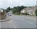
Dewstow Road, Caldicot
On the NW edge of Caldicot, Dewstow Road heads away from the B4245.
At lower left is the turning for Fairfield Close; on the right, the turning for Birbeck Road.
Image: © Jaggery
Taken: 14 Aug 2010
0.22 miles
8
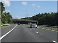
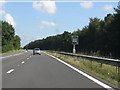
M48 Motorway - minor road overbridge near Rogiet
This interesting style of structure with one plain abutment and a semi-arch forming a single span across the motorway is used for several road bridges between Magor and the original Severn Bridge. For another example, see: http://www.geograph.org.uk/photo/2059804
Image: © J Whatley
Taken: 31 Aug 2010
0.22 miles
9
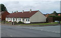
Corner of Firs Road and Green Lane, Caldicot
A row of bungalows on Green Lane, at the corner of Firs Road. A similar row is on the opposite corner. http://www.geograph.org.uk/photo/2011708
Image: © Jaggery
Taken: 14 Aug 2010
0.24 miles
10
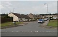
Firs Road, Caldicot
Viewed from Green Lane. On the left, next to the white bungalow, is the turning for Maple Close.
Image: © Jaggery
Taken: 14 Aug 2010
0.24 miles