IMAGES TAKEN NEAR TO
Rogiet, CALDICOT, NP26 3UP
Introduction
This page details the photographs taken nearby to NP26 3UP by members of the Geograph project.
The Geograph project started in 2005 with the aim of publishing, organising and preserving representative images for every square kilometre of Great Britain, Ireland and the Isle of Man.

There are currently over 7.5m images from over14,400 individuals and you can help contribute to the project by visiting https://www.geograph.org.uk
Image Map
Images are licensed for reuse under creativecommons.org/licenses/by-sa/2.0
Notes
- Clicking on the map will re-center to the selected point.
- The higher the marker number, the further away the image location is from the centre of the postcode.
Image Listing (43 Images Found)
Images are licensed for reuse under creativecommons.org/licenses/by-sa/2.0
Image
Details
Distance
1
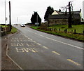
Llanfihangel Rogiet bus stop near Green Farm
This stop alongside the B4245 is for eastbound buses. In January 2016, the bus stop sign shows routes 62 74 X14.
Image: © Jaggery
Taken: 24 Jan 2016
0.01 miles
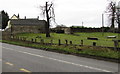
2
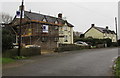
Scaffolding on Court Cottages, Llanfihangel Rogiet
Four semi-detached cottages are located on the north side of the B4245, opposite Green Farm.
Scaffolding on the left is on Court Cottages in late January 2016. Green Farm Cottages are on the right.
Image: © Jaggery
Taken: 24 Jan 2016
0.02 miles
3
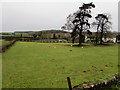
Sheep in a Llanfihangel Rogiet field
Viewed from St Michael and All Angels churchyard looking towards the B4245.
Image: © Jaggery
Taken: 24 Jan 2016
0.02 miles
4
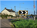
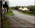
Warning chevron sign on the B4245 at Llanfihangel Rogiet
Image: © Ruth Sharville
Taken: 5 Mar 2012
0.03 miles
5
Green Farm, Llanfihangel Rogiet
Viewed across the B4245 in rural Monmouthshire.
Image: © Jaggery
Taken: 24 Jan 2016
0.04 miles
6

Four semi-detached cottages, Llanfihangel Rogiet
Located on the north side of the B4245, opposite Green Farm.
On the left are Court Cottages; on the right, Green Farm Cottages.
Image: © Jaggery
Taken: 14 Aug 2010
0.04 miles
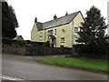
7

Farmhouse, Green Farm, Llanfihangel
Viewed from the B4245.
Image: © Jaggery
Taken: 14 Aug 2010
0.04 miles
8
Bus stop near Green Farm, Llanfihangel Rogiet
This stop alongside the B4245 is for westbound buses, towards Newport.
In January 2016, the bus stop sign shows routes 62 74 X14.
Image: © Jaggery
Taken: 24 Jan 2016
0.05 miles
9
Farmhouse, Green Farm, Llanfihangel Rogiet
On the south side of the B4245 in rural Monmouthshire.
Image: © Jaggery
Taken: 24 Jan 2016
0.05 miles
10
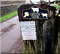
Green Farm name sign, Llanfihangel Rogiet
On the right side of this http://www.geograph.org.uk/photo/4811814 entrance.
Pedestrians can use the route through Green Farm to access St Michael's Church.
Vehicle drivers wishing to access the church should park in this http://www.geograph.org.uk/photo/4811706 adjacent layby.
Image: © Jaggery
Taken: 24 Jan 2016
0.05 miles