IMAGES TAKEN NEAR TO
Cherry Close, CALDICOT, NP26 3SQ
Introduction
This page details the photographs taken nearby to Cherry Close, NP26 3SQ by members of the Geograph project.
The Geograph project started in 2005 with the aim of publishing, organising and preserving representative images for every square kilometre of Great Britain, Ireland and the Isle of Man.

There are currently over 7.5m images from over14,400 individuals and you can help contribute to the project by visiting https://www.geograph.org.uk
Image Map
Images are licensed for reuse under creativecommons.org/licenses/by-sa/2.0
Notes
- Clicking on the map will re-center to the selected point.
- The higher the marker number, the further away the image location is from the centre of the postcode.
Image Listing (17 Images Found)
Images are licensed for reuse under creativecommons.org/licenses/by-sa/2.0
Image
Details
Distance
1
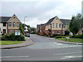
Chestnut Drive, Rogiet
Viewed across Rogiet Road (B4245)
Image: © Jaggery
Taken: 14 Aug 2010
0.09 miles
2
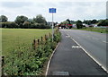
Welsh 6 English 2, Rogiet Road
A blue sign at the edge of Rogiet Road, on the western approach to the village of Rogiet, commands
CYCLISTS DISMOUNT in English and
BEICWYR DEWCH ODDI AR EICH BEIC in Welsh.
My knowledge of Welsh is rudimentary, but a rough translation is 'bikers get down from your bikes.'
I don't know whether as a general rule, Welsh needs more words than English, but perhaps the Welsh is clearer to younger Welsh speakers. A young English-speaking cyclist may not yet have learnt what 'dismount' means.
A more pertinent point is, what are cyclists meant to do at this point? The edge of the village of Rogiet is about 100 metres away. The road from Caldicot is usually busy.
Image: © Jaggery
Taken: 14 Aug 2010
0.10 miles
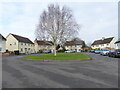
5
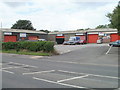
Cheeseman's Trading Estate, Rogiet
The small trading estate is a group of businesses arranged along three sides of a rectangle on the north side of the B4245, near the eastern edge of Rogiet.
Image: © Jaggery
Taken: 14 Aug 2010
0.13 miles
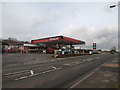
6
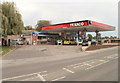
Texaco filling station, Rogiet
Filling station and shop located on the B4245 at the eastern end of Rogiet.
Image: © Jaggery
Taken: 14 Aug 2010
0.13 miles
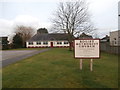
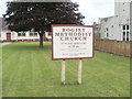
9
Rogiet Methodist Church
The church is set back 30 metres from Ifton Road, near the crossroads with Westway and Grenville Terrace. The church was built in 1933 from donations made by railwaymen working at Severn Tunnel Junction, and their families.
Image: © Jaggery
Taken: 14 Aug 2010
0.18 miles
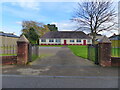
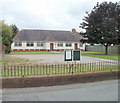
10
Lawn, Rogiet Methodist Church
A lawn 30 metres long leads from Ifton Road to Rogiet Methodist Church. http://www.geograph.org.uk/photo/2015038
Image: © Jaggery
Taken: 14 Aug 2010
0.18 miles