IMAGES TAKEN NEAR TO
School Park, Dancing Hill, CALDICOT, NP26 3LX
Introduction
This page details the photographs taken nearby to School Park, Dancing Hill, NP26 3LX by members of the Geograph project.
The Geograph project started in 2005 with the aim of publishing, organising and preserving representative images for every square kilometre of Great Britain, Ireland and the Isle of Man.

There are currently over 7.5m images from over14,400 individuals and you can help contribute to the project by visiting https://www.geograph.org.uk
Image Map
Images are licensed for reuse under creativecommons.org/licenses/by-sa/2.0
Notes
- Clicking on the map will re-center to the selected point.
- The higher the marker number, the further away the image location is from the centre of the postcode.
Image Listing (179 Images Found)
Images are licensed for reuse under creativecommons.org/licenses/by-sa/2.0
Image
Details
Distance
1
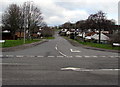
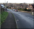
Dancing Hill, Magor
Dancing Hill (Bryn Dawnsio in Welsh) ascends from the B4245 Main Road.
The left turn 60 metres ahead is into the cul-de-sac Cowleaze. https://www.geograph.org.uk/photo/5678391
Beyond the Cowleaze junction, Dancing Hill crosses over Mill Reen https://www.geograph.org.uk/photo/5678400 which here marks the Magor/Undy boundary.
Image: © Jaggery
Taken: 4 Feb 2018
0.02 miles
2
Deciduous tree and its shadow, Dinch Hill, Undy
Viewed on February 11th 2018. It is likely to be many weeks before this tree is in leaf again.
Image: © Jaggery
Taken: 11 Feb 2018
0.02 miles
3
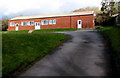
Undy Memorial Hall, Dinch Hill Lane, Undy
Viewed in February 2018 when there is no name sign in view nor nearby.
Image: © Jaggery
Taken: 11 Feb 2018
0.02 miles
4
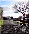
Dinch Hill, Undy
Cul-de-sac on the south side of Dancing Hill.
Image: © Jaggery
Taken: 11 Feb 2018
0.03 miles
5
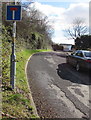
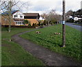
Down Dancing Hill, Undy
Dancing Hill descends from Undy towards Magor. The Dinch Hill junction is on the left.
Image: © Jaggery
Taken: 11 Feb 2018
0.03 miles
6
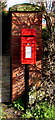
Queen Elizabeth II postbox, Dinch Hill Lane, Undy
On the right here. https://www.geograph.org.uk/photo/5678546
The maker's name embossed on the bottom of the box is
CARRON COMPANY STIRLINGSHIRE.
Image: © Jaggery
Taken: 11 Feb 2018
0.03 miles
7
Western end of Dinch Hill Lane, Undy
Viewed across Dancing Hill. Dinch Hill Lane leads to the cul-de-sac Mill Reen. https://www.geograph.org.uk/photo/5678534
Image: © Jaggery
Taken: 11 Feb 2018
0.04 miles
8
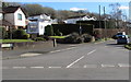
Millfield Park, Undy
Cul-de-sac viewed across Dancing Hill.
Image: © Jaggery
Taken: 11 Feb 2018
0.04 miles
9
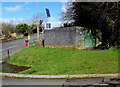
Dinch Hill electricity substation, Undy
The Western Power Distribution electricity substation is on the corner of Dinch Hill and Dancing Hill.
Its identifier is DINCH HILL S/S 536699.
Image: © Jaggery
Taken: 11 Feb 2018
0.04 miles
10
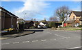
Bend in the Dancing Hill pavement, Undy
On the west side of Dancing Hill viewed from the corner of Cowleaze.
This part of Dancing Hill is in Undy. The southern part of the hill (behind the camera) is in Magor.
Image: © Jaggery
Taken: 11 Feb 2018
0.05 miles