IMAGES TAKEN NEAR TO
The Hendre, MONMOUTH, NP25 5SX
Introduction
This page details the photographs taken nearby to NP25 5SX by members of the Geograph project.
The Geograph project started in 2005 with the aim of publishing, organising and preserving representative images for every square kilometre of Great Britain, Ireland and the Isle of Man.

There are currently over 7.5m images from over14,400 individuals and you can help contribute to the project by visiting https://www.geograph.org.uk
Image Map
Images are licensed for reuse under creativecommons.org/licenses/by-sa/2.0
Notes
- Clicking on the map will re-center to the selected point.
- The higher the marker number, the further away the image location is from the centre of the postcode.
Image Listing (41 Images Found)
Images are licensed for reuse under creativecommons.org/licenses/by-sa/2.0
Image
Details
Distance
1
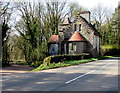
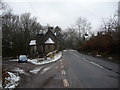
Derelict North Lodge, Hendre, Monmouthshire
At the March 2017 date of this photo, North Lodge has been derelict for many years. The Cadw website states that the building was designed by Aston Webb c1896 in the Scottish baronial style at the wish of Georgiana, the wife of John Allan Rolls. Georgiana was the daughter of Sir Charles Maclean of Morvaren, Scotland.
North Lodge was Grade II listed in 2001.
Image: © Jaggery
Taken: 26 Mar 2017
0.01 miles
2
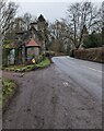
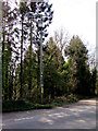
Towards a bend in the B4233 near Hendre, Monmouthshire
Ahead for Hendre. Behind the camera for Rockfield and Monmouth.
Derelict North Lodge https://www.geograph.org.uk/photo/5325582 is on the left.
Image: © Jaggery
Taken: 23 Jan 2022
0.02 miles
3
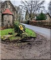
Wonky yellow sign alongside the B4233 near Hendre
Not perpendicular in January 2022, the sign shows "DANGER OF DEATH - ELECTRIC OVERHEAD LINE". The text is also in Welsh. Derelict North Lodge https://www.geograph.org.uk/photo/5325582 is on the left.
Image: © Jaggery
Taken: 23 Jan 2022
0.02 miles
4
Three wordless prohibitions near Hendre, Monmouthshire
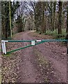
Each with a diagonal red line on a depiction of a motor vehicle. Located beyond the right edge of this https://www.geograph.org.uk/photo/7091746 barrier across an entrance to woodland.
Image: © Jaggery
Taken: 23 Jan 2022
0.02 miles
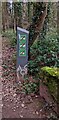
5
Barrier across an entrance to a Natural Resources Wales site near Hendre
A notice on the metal barrier shows "No parking - Gate in constant use". The text is also in Welsh.
Image: © Jaggery
Taken: 23 Jan 2022
0.02 miles
6
Disused lodge near The Hendre
A sad and forlorn boarded-up old lodge building.
Image: © Jeremy Bolwell
Taken: 23 Mar 2013
0.02 miles
7
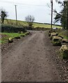
Boulder-lined access road to woodland near Hendre, Monmouthshire
From the B4233 to woodland https://www.geograph.org.uk/photo/7091768 behind the camera.
Image: © Jaggery
Taken: 23 Jan 2022
0.02 miles
8
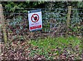
DIM PARCIO/NO PARKING notice near Hendre, Monmouthshire
National Resources Wales Welsh / English notice on a fence alongside a woodland access road from the B4233.
Image: © Jaggery
Taken: 23 Jan 2022
0.02 miles
9
Line spur pole alongside the B4233, Hendre, Monmouthshire
The Western Power Distribution line spur pole,
identifier S/S 532900, is near the derelict former North Lodge. http://www.geograph.org.uk/photo/5325582
Image: © Jaggery
Taken: 26 Mar 2017
0.03 miles
10
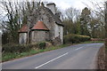
Abandoned lodge
The abandoned lodge beside the B4233 is one of the former entrances to Hendre, the former home of the Rolls family (Rolls Royce). The house and grounds is now a golf club.
Image: © Philip Halling
Taken: 15 Mar 2014
0.03 miles