IMAGES TAKEN NEAR TO
Rockfield, MONMOUTH, NP25 5SW
Introduction
This page details the photographs taken nearby to NP25 5SW by members of the Geograph project.
The Geograph project started in 2005 with the aim of publishing, organising and preserving representative images for every square kilometre of Great Britain, Ireland and the Isle of Man.

There are currently over 7.5m images from over14,400 individuals and you can help contribute to the project by visiting https://www.geograph.org.uk
Image Map
Images are licensed for reuse under creativecommons.org/licenses/by-sa/2.0
Notes
- Clicking on the map will re-center to the selected point.
- The higher the marker number, the further away the image location is from the centre of the postcode.
Image Listing (11 Images Found)
Images are licensed for reuse under creativecommons.org/licenses/by-sa/2.0
Image
Details
Distance
1
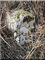
Old Milestone by the B4233, Steppes Farm Cottages, Llangattock Vibon Avel
Stone post by the B4233, in parish of Llangattock Vibon Avel (Monmouthshire District), West of Steppes Farm Cottages, North side of road.
Inscription once read:-
: (Abergavenny / 11) : : (Monmouth / 3) :
Surveyed
Milestone Society National ID: MON_MMAG03
Image: © Milestone Society
Taken: Unknown
0.04 miles
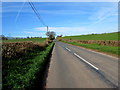
2
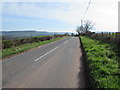
East along the B4233 towards Rockfield, Monmouthshire
Extending for 23km (c14 miles) from Abergavenny to Monmouth, the B4233 is a rural B-road in Monmouthshire.
Ahead for Monmouth via Rockfield.
Image: © Jaggery
Taken: 26 Mar 2017
0.05 miles
3
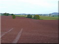
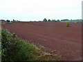
Red soil of Monmouthshire
Looking north from the B4233 at a recently cultivated arable field.
Those aren't my tyre tracks!
Image: © Jonathan Billinger
Taken: 24 Oct 2008
0.06 miles
4
The B4233 Rockfileld Rock
The B4233, Rockfield Road between Monmouth and Rockfield.
Image: © Philip Halling
Taken: 14 Jan 2012
0.09 miles
5
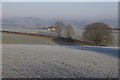
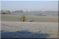
Farmland near the Monnow valley
Farmland on a frosty January morning on the southern side of Monnow valley, viewed from the B4233 to the west of Monmouth.
Image: © Philip Halling
Taken: 14 Jan 2012
0.11 miles
6
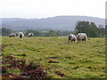
Sheep in pasture
View south-east from the B4233 west of Rockfield.
The hill in the distance is The Kymin.
Image: © Jonathan Billinger
Taken: 24 Oct 2008
0.12 miles
7
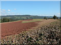
More red soil
Looking west, parallel to the B4233, west of Rockfield.
Image: © Jonathan Billinger
Taken: 24 Oct 2008
0.13 miles
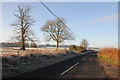
8
Field being ploughed near Steps Farm
View to the north-east, the high ground on the horizon is in England.
Image: © Philip Halling
Taken: 23 Sep 2006
0.18 miles
9
Monmouthshire farmland
View across rolling Monmouthshire farmland viewed from Rockfield Road to the west of Monmouth.
Image: © Philip Halling
Taken: 14 Jan 2012
0.20 miles
10
West along the B4233 towards Hendre, Monmouthshire
Extending for 23km (c14 miles) from Monmouth to Abergavenny, the B4233 is a rural B-road in Monmouthshire.
Image: © Jaggery
Taken: 26 Mar 2017
0.22 miles