IMAGES TAKEN NEAR TO
Buckholt, MONMOUTH, NP25 5RZ
Introduction
This page details the photographs taken nearby to NP25 5RZ by members of the Geograph project.
The Geograph project started in 2005 with the aim of publishing, organising and preserving representative images for every square kilometre of Great Britain, Ireland and the Isle of Man.

There are currently over 7.5m images from over14,400 individuals and you can help contribute to the project by visiting https://www.geograph.org.uk
Image Map
Images are licensed for reuse under creativecommons.org/licenses/by-sa/2.0
Notes
- Clicking on the map will re-center to the selected point.
- The higher the marker number, the further away the image location is from the centre of the postcode.
Image Listing (22 Images Found)
Images are licensed for reuse under creativecommons.org/licenses/by-sa/2.0
Image
Details
Distance
1
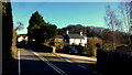
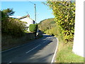
Cottages at Buckholt
The houses are squeezed between the road and the drop to the Mally Brook to the right out of shot.
Looking north towards Hereford.
Image: © Jonathan Billinger
Taken: 28 Jan 2019
0.01 miles
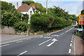
2
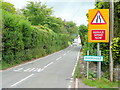
A466 Hereford Road, Buckholt
Looking north.
Image: © Jonathan Billinger
Taken: 14 Jul 2009
0.02 miles
3
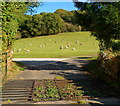
Grazing sheep, Buckholt
Sheep graze in a field located between the A466 and Grist Castle Wood.
Image: © Jaggery
Taken: 22 Oct 2011
0.02 miles
4
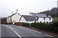
Cottages at Buckholt
Looking north towards Hereford.
Image: © Jonathan Billinger
Taken: 18 Dec 2006
0.02 miles
5
A466, Buckholt
Viewed from the edge of a small farm building.http://www.geograph.org.uk/photo/2662440 Ahead, the old road to Hereford
runs along the Welsh edge of the border with England. The A466 crosses into England (Herefordshire) about a mile ahead.
Image: © Jaggery
Taken: 22 Oct 2011
0.04 miles
6
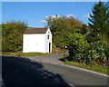
Small farm building, Buckholt
Antlers are embedded in the roof triangle on the right side of the building, located on the edge of the A466 (Hereford Road or Old Hereford Road).
Image: © Jaggery
Taken: 22 Oct 2011
0.04 miles
7
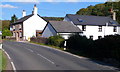
Buckholt houses
Houses on the east side of the A466 ((Old) Hereford Road) in the hamlet of Buckholt, Monmouthshire.
Image: © Jaggery
Taken: 22 Oct 2011
0.04 miles
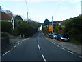
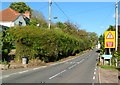
9
Hereford Road, Buckholt
Hereford Road, the A466 passing through Buckholt.
Image: © Philip Halling
Taken: 21 Sep 2013
0.07 miles
10
Southern boundary of Buckholt, Monmouthshire
Hereford Road (A466), from Monmouth, reaches the hamlet of Buckholt.
Image: © Jaggery
Taken: 22 Oct 2011
0.07 miles