IMAGES TAKEN NEAR TO
Llanrothal, MONMOUTH, NP25 5QL
Introduction
This page details the photographs taken nearby to NP25 5QL by members of the Geograph project.
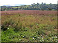
The Geograph project started in 2005 with the aim of publishing, organising and preserving representative images for every square kilometre of Great Britain, Ireland and the Isle of Man.

There are currently over 7.5m images from over14,400 individuals and you can help contribute to the project by visiting https://www.geograph.org.uk
Image Map
Images are licensed for reuse under creativecommons.org/licenses/by-sa/2.0
Notes
- Clicking on the map will re-center to the selected point.
- The higher the marker number, the further away the image location is from the centre of the postcode.
Image Listing (8 Images Found)
Images are licensed for reuse under creativecommons.org/licenses/by-sa/2.0
Image
Details
Distance
1
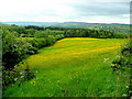
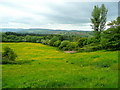
The Monnow valley 3
Buttercup yellow dominates the palette in this view towards Tregate Warren.
Image: © Jonathan Billinger
Taken: 22 May 2009
0.15 miles
2
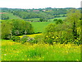
The Monnow valley 4
Looking across the Welsh border towards Rockfield.
The buttercups really are at their peak right now!
Image: © Jonathan Billinger
Taken: 22 May 2009
0.17 miles
3
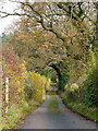
Road to The Cote
Nothing to indicate whether private or not.
Image: © Jonathan Billinger
Taken: 20 Nov 2014
0.20 miles
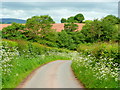
4
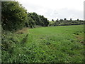
Field at Tregate
Looking across the valley of the River Monnow towards the Monmouthshire side.
Image: © Jonathan Thacker
Taken: 12 Sep 2018
0.20 miles
5
Field of potatoes in the Monnow valley
Field of potatoes to the south of Tregate Farm. This crop of potatoes will be harvested in the next few weeks.
Image: © Philip Halling
Taken: 23 Sep 2006
0.20 miles
6
The Monnow valley 2
Viewed from the lane just east of The Cwm.
The yellow is buttercup.
Image: © Jonathan Billinger
Taken: 22 May 2009
0.22 miles
7
Tregate Lane in spring
Herefordshire/Monmouthshire border country by the Monnow.
Image: © Jonathan Billinger
Taken: 22 May 2009
0.23 miles
8
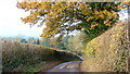
Tregate Lane
The outline of one of the buildings at Tregate can be seen distant left.
Image: © Jonathan Billinger
Taken: 20 Nov 2014
0.23 miles