IMAGES TAKEN NEAR TO
Rockfield, MONMOUTH, NP25 5QE
Introduction
This page details the photographs taken nearby to NP25 5QE by members of the Geograph project.
The Geograph project started in 2005 with the aim of publishing, organising and preserving representative images for every square kilometre of Great Britain, Ireland and the Isle of Man.

There are currently over 7.5m images from over14,400 individuals and you can help contribute to the project by visiting https://www.geograph.org.uk
Image Map
Images are licensed for reuse under creativecommons.org/licenses/by-sa/2.0
Notes
- Clicking on the map will re-center to the selected point.
- The higher the marker number, the further away the image location is from the centre of the postcode.
Image Listing (9 Images Found)
Images are licensed for reuse under creativecommons.org/licenses/by-sa/2.0
Image
Details
Distance
1
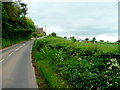
B4347 to Newcastle, Monmouthshire
Looking north-west from near Rockfield.
Image: © Jonathan Billinger
Taken: 22 May 2009
0.13 miles
2
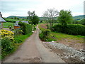
Old Mill Lane
A private road to Old Mill House and Perthyre Farm looking from the B4347 north of Rockfield.
Image: © Jonathan Billinger
Taken: 22 May 2009
0.14 miles
3
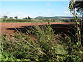
Southeasterly view from B4347
I had stopped my car in a nearby layby on my way from Monmouth to Skenfrith and noticed that I had covered 4 miles. From here, one can just make out Monmouth in the far distance (to the left of the rounded 'blue' hill).
Image: © John Baker
Taken: 1 Apr 2011
0.14 miles
4
B4347 at Old Mill Lodge, with hot air balloon landing
Image: © Colin Pyle
Taken: 6 May 2012
0.17 miles
5
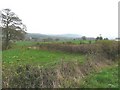
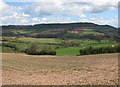
Ploughed field to the north of Rockfield
A footpath follows the right edge of this recently ploughed field, the footpath leads to Perthyre Farm.
Image: © Philip Halling
Taken: 23 Sep 2006
0.19 miles
6
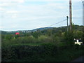
View towards Buckholt Wood
Across rape stubble.
Image: © Pauline E
Taken: 7 Apr 2009
0.21 miles
7
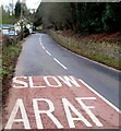
Slow at the northern approach to Rockfield
The bilingual message (in English and Welsh) is on the surface of the B4347 in NE Monmouthshire. Ahead, at the left edge of the view, is a small sign showing Rockfield. From 2004-2011 there was a bigger sign here, showing ROCKFIELD and LLANORONWY. See http://www.geograph.org.uk/photo/3551542 for the reason the larger sign was replaced.
Image: © Jaggery
Taken: 22 Jan 2012
0.23 miles
8
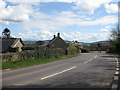
B4347 passing Pool Farm
Heading for Rockfield.
Image: © Pauline E
Taken: 7 Apr 2009
0.23 miles
9
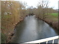
River Monnow north of Rockfield Bridge, Rockfield
The river flows towards this bridge http://www.geograph.org.uk/photo/3551874 in the NE Monmouthshire village.
Image: © Jaggery
Taken: 22 Jan 2012
0.25 miles